7.1 INTRODUCTION
In this
chapter we are concerned more specifically with spatial relations within the
individual urban or metropolitan area.1 Such an
area includes a principal city with an intensively developed core or downtown
area (the central business district, or CBD) and a surrounding fringe of
suburbs and satellites linked to the principal city by trade, commutation, and
other socioeconomic interaction.
It would be
hard to think of any significant question or proposition of urban economics not
involving space, distance, or location as a fundamental concern, since the
essence of a city lies in the close proximity of diverse activities and
persons. So urban economics is just part of the broader field of spatial or
regional economics. But it is such a large part that it is often studied as a
distinct entity. Our intention in this chapter is not to survey urban economics
as a field of study but to expose some essential aspects of the spatial
structure of urban economies. In this way, it will be possible to affirm some
principles of spatial economics that are particularly relevant and useful in
understanding the development of cities and their problems.
7.2 SOME LOCATION FACTORS
The
land-use analysis that was developed in Chapter 6 allowed us to identify a number of characteristics associated with urban
activities which implied a willingness to bid high rents for the more central
locations. The movement of people and the importance of direct face-to-face
contact contribute to the advantages of central locations for these activities.
The applicable transfer rates are high, and linkages among nonresidential
activity units, among households, and among residential units and
nonresidential units are substantial. Further, the realization of agglomeration
economies most often requires close and frequent contact. These economies
enhance the attractiveness of central locations and tend to bring units
together, not merely in the same city but in the same district of a
city.
7.2.1 Independent Locations
While these access and agglomerative factors are quite important in
explaining the outcome of the bidding process by which land is allocated among
competing urban uses, it is necessary to recognize that some kinds of locations
within an urban area can be regarded as independently determined. In fact,
there are two distinct bases for exogenous determination of locations in an
urban area. For some activities, certain topographical or other natural site
features are essential; this means that the lie of the land narrows the choice
to one or a very small number of locations. Ports for water traffic illustrate
this, and there are some urban areas where the topography limits airport sites
almost as drastically. In the distant past, considerations of defense played a
major part in locating the heart of the city and the city itself. Localized
recreational facilities such as beaches also illustrate this kind of factor,
and in a few urban areas extractive industries (mainly mining) occur and are,
of course, limited to certain special sites.
There is a
further type of exogenously determined location where the independent influence
arises not from site features as much as from the fact that the activity
requires contact with the outside world. Not just water ports but all kinds of
terminal and interarea transport activities come under this head. Since there
are great economies of scale in interregional transport and in terminal
handling of goods, the urban area’s gateways to and from the outside world
constitute a set of focal points, whose locations within the area help to
determine—rather than just being determined by—the other activities
of the area. This does not mean, of course, that such terminal locations are
absolutely and permanently unresponsive to the changing patterns of other
activities in the area served. Such terminals are from time to time shifted so
as to improve local accessibility or to make way for more insistent claimants
for the space. But the terminal locations do play an active role in shaping the
pattern and are to be viewed as part of the basic framework around which other
activities are fitted.
7.2.2 The Center
There is
also a strong element of exogenous determination in the location of the point
of "maximum overall accessibility" within the urban area. If we think of this,
for example, as the place where all the people of the area could assemble with
the least total man-miles of travel, it is the "median center of population"
and would seem to depend simply upon the location of the various types of
residence. But travel is cheaper and faster along developed routes, and the
cost and layout of these routes are affected by scale (traffic volume) and
topography. Thus, evaluated in terms of travel cost and time, the focal
maximum-access point can be regarded as a rather stable datum, even though the
extent and importance of its access advantage over other points can change
radically. In major American urban areas, despite great overall growth,
far-reaching change, and redistribution of activities, this focal point has
usually shifted only a relatively short distance over periods measured in
decades and generations; and the earlier central foci are well within what we
currently recognize as the central business district.
This
concept of a single "most central" focal point in an urban area is significant
and useful in developing simplified bases for understanding the overall
pattern. Obviously, it has its limitations, some of which will be discussed now
and others later. First, there are really a variety of distinguishable central
points of this sort, depending on what kinds of people or things we are
imagining to be assembled with a minimum of total expense or effort. The
employed workers of the area are not distributed in quite the same pattern as
the total population, the shopping population, the school-attending population,
the office workers, the industrial blue-collar workers, the theater-going or
the library-using population; there might be a different optimum location from
the standpoint of access to each of these types of people. Where goods rather
than people are moving (for example, in the case of wholesale activity or
production serving such local needs as daily newspapers or bread), the
transport conditions are different, and this may again mean a different
optimum-access point. Second, we have to recognize that, in varying degrees,
the concept of one single point serving as the origin or destination for all
flows of a specified type is unrealistic, and defensible only as a convenient
fiction. Thus if we identify some central point as having best access to the
homes of the entire clerical office force of an urban area, this does not imply
that all offices should logically be concentrated there. What it does imply is
that, solely from the standpoint of commuting access for the clerical workers
and ignoring claims of alternative uses of space, it would make sense for the
density of clerical employment to peak at that point.
7.2.3 Neighborhood Externalities
In gaining
perspective on the role of access and agglomerative factors in urban location
decisions, it is also necessary to recognize that proximity can have
unfavorable as well as favorable effects. "Neighborhood character’
‘—in terms of cleanliness, smells, noise, traffic congestion, public
safety, variety interest, and general appearance—is important in
attracting some kinds of use and repelling others. Prestige types of residence
or business are, of course, particularly sensitive to this kind of advantage,
which is often more important than any access consideration as such.
High-income householders may be willing to lengthen their work journey greatly
for the sake of neighborhood amenity or agreeable surroundings.
The usual
effect of this type of consideration is to make neighborhoods more homogeneous
within themselves and more unlike other neighborhoods: a tendency toward areal
specialization by uses, or "segregation" in the broad sense.2 With few exceptions, a given type of activity finds
advantage in being in a neighborhood devoted to reasonably similar kinds of
uses, and disadvantage in being in violent contrast to the neighborhood
pattern. Zoning controls and planned street layouts play a part in reinforcing
this tendency.
7.2.4 Scale Economies and Urban Land Use
Many of the
points just raised imply that the broad continuous zones of economic activity
suggested by von Thünen’s simplified model of patterns of land use in Chapter 6 would be substantially modified in an
intraurban setting. When that model is applied to such extensive activities as
agricultural or residential land users, it is not really necessary to consider
the size of the individual location unit in terms of output or occupied land
area, since such zones contain a large number of adjacent units. Accordingly,
in that instance, we look for explanations of rent-paying ability and location
in terms of inputs, costs, outputs, and rents on a per-acre basis. We could
appropriately consider costs as affected by intensity of land use rather than
by the size of the producing unit, the firm, or the cluster.
Consider,
however, an activity such as university education, which on the basis of its
production characteristics can best be located, say, 5 miles from the center of
the metropolitan area supplying the bulk of the students. A more central
location would mean excessive land costs, while a less central one would mean
poor access to the homes of the commuting students and perhaps also to various
other urban activities with which contact is desired. If we brashly apply the
basic von Thünen model, we get the answer that a university should occupy
a ring-shaped zone with a 5-mile radius. If the amount of space needed were,
say, 300 acres, the ring-shaped campus would be about 80 feet wide and more
than 31 miles long. Since such a layout would preclude both having a sizable
stadium and getting to classes on time, it is clearly unacceptable. In the
interest of its own internal logistics, the university would prefer a blob to a
doughnut. Two different institutions in the same city might find some
external-economy advantage in being close to one another in a single
"university district," but if they are intensely competing for commuter
students, they might prefer to locate on opposite sides of town.
The point
here is that a university campus is a location unit subject to considerable economies of scale, so that there will be only a few unit locations,
perhaps only one, in any given urban area; at the same time it is sufficiently
space using to need an off-center or even suburban location. The same principle
applies to any activity with these characteristics. As a result, the concentric
ring pattern appears within urban areas only with respect to certain broad
classes of activities such as residence. For other noncentral uses, the pattern
can range from scattered fragments of a ring to a single off-center
concentration. Still further complication is introduced by the fact that each
such concentration can become a focal point for a neighborhood constellation of
associated land uses. Any sizable urban area contains a number of such
subcenters in addition to the principal downtown center.
7.3 SYMMETRICAL MONOCENTRIC MODELS OF URBAN FORM
7.3.1 Bases of Simplification
A number of
factors relevant to intraurban location decisions have been catalogued above,
but basically there are three kinds of considerations that determine the
relative desirability of locations for individual location units, such as
households or business establishments. These are (1) environmental
characteristics, (2) access, and (3) cost. They reflect the fact that the users
of a site are concerned with it in three distinct ways. They occupy it,
as residents or producers, and are thus concerned with its "site and
neighborhood," or immediate environmental qualities. They, as well as goods and
services, move between this site and others and are therefore concerned
with its convenience of access to other places. Finally, they have to pay for its use and are therefore concerned with its cost.
It should
be evident now that in reducing the complex factor of access within an urban
area to the simple form of proximity to a single focal point—as was done
in Chapter 6—some important aspects of urban
economic activity are put aside. Within a city, it is as if all intraurban
journeys were to or from downtown and all shipments of goods also passed
through downtown.3Additionally, such an analysis
eliminates all differentiation of sites with respect to topography, amenity,
and environmental advantage. These two simplifications also imply ignoring the
manifold types of external-economy effects and environmental attractions and
repulsions that have been discussed. In effect, each type of activity is
thought of as being independently attracted (by access considerations) toward
the urban center. The only interdependence among the locations of the various
activities arises, then, from the fact that they are bidding against one
another for space.
Nevertheless, as a starting point for understanding urban spatial
structure, monocentric models can be very useful. While they abstract
from some important features of the urban environment, they expose others that
are fundamental in understanding urban spatial patterns.
7.3.2 The Density Gradient
Perhaps the
most elementary aspect of an urban pattern that is illuminated by monocentric
models such as those discussed in Chapter 6 is the
way in which intensity of land use varies with distance from the center.
Implicit here is the concept of a city as a multitude of space-occupying
location units seeking close contact. If these location units are affected by
more or less the same kind of access attraction (as, for example, households
are affected by the desire to shorten the journey to work) and have some leeway
in the amount of space they occupy, we should expect their density (intensity
of space use) to be at a peak at the center (the optimum total-access point)
and to fall off in all directions with increasing distance from the center.
Such a tendency can be described by a density gradient, where density is
a negative function of radial distance.
In this
simple scheme, the decline of density with distance depends (1) on the rate at
which the area’s noncentral activity units (households, in a purely
residential journey-to-work model) are willing to trade off spaciousness of
home sites against a quicker or cheaper journey to the center (reflecting lower
land rents with increased distance from the CBD), and (2) on the time and money
cost of transport. Obviously, a variety of circumstances—such as better
transport in some directions than in others and variations in site
quality—can complicate this neat symmetrical picture in the real
world.
As Colin
Clark has demonstrated, the gradient of population density with respect to
radial distance, in a wide selection of large modern cities, has a consistent
shape, identifiable as an exponential function. The exponential shape of the
density gradient is predicted by virtually all monocentric models of urban land
use,4and consistent with this prediction, Clark
found that residential density does tend to fall by a uniform percentage with
each unit increase in distance from the center. Density gradients can therefore
be specified by two parameters: D0, the peak density at the
center, and b, a slope factor, in the following formula:
Dx=D0 e -
bx
where x represents radial distance and e is 2.718 ..., the base
of natural logarithms.5Several actual gradients are
shown in Figure 7-1.
Since this
particular conformation describes residential density, it fits in only
those parts of the urban area that are primarily residential. The "peaking" of
residential densities actually resembles a volcano more than a sharp conical
mountain peak. There is a crater of lower density in the innermost zone, where
nonresidential activities predominate. The D0parameter in
the gradient formula is thus fictional, representing an extrapolation to what
the gross residential density would theoretically be at the center if
nonresidential uses did not preempt the most central locations. Alternatively,
it is possible (though more difficult in terms of data availability) to
construct the gradient on the basis of net residential density.6
More recent
analysis by Muth, Berry, Alonso, Mills, and others has confirmed the prevalence
of this exponential form of residential density gradient, and has developed and
begun to test some useful explanatory hypotheses about its determinants.7
In brief,
it appears that:
1. Larger
cities have, in addition to higher central densities, lower slope coefficients
(i.e., flatter slope).
2. The
observed decline of population per acre with increased distance from the city
center is actually a combination of at least three different gradients. As we
go outward from the center, the number of housing units per acre falls, and so
does the proportion of people living outside of households (for example, in
institutions, hotels, and rooming houses); but the declining density effect of
those two variables is partially offset by rising household size.
3. The central density is largely determined by conditions (such as transport,
communication, production technology, income levels, and occupation structure)
during the period when the city became established. Once set, the basic form of
the city (particularly in the central area where investment in structures is
heaviest) is subject to considerable inertia. At any given time, then, the age of a city (definable in terms of the date at which it attained some
specified minimum size, such as 50,000) is highly correlated with its central
density. The familiar dichotomy between newer American "auto-oriented" cities
such as Phoenix and older "pre-auto" cities recognizes this effect.
Perhaps the
most intensive statistical analysis of urban residential density gradients is
to be found in Richard Muth’s work. After a series of statistical tests of
the relation of distance to gross residential density figures in 46 U.S. cities
in 1950 (based on samples of 25 Census tracts in each city), he concluded that
"the negative exponential function in distance from the CBD [Central Business
District] alone fits population density data for American cities in 1950 rather
well."8 This held true despite the fact that there
were numerous deviations from regularity and that the exponential formula as a
regression equation accounted for only about half of the observed intracity
variation of density (among tracts within any city). The fitted density
gradients varied widely in their slopes, with b ranging from 0.18 to
1.2. These b values correspond to density declines of 17 percent and 70
percent respectively for each mile of distance.
Muth then
looked for factors to explain why some cities had steeper density gradients
than others. He found that flatter gradients (that is, lower values for b) were significantly associated with each of the following characteristics of
the urban area:
• High
automobile ownership
• High
income level
• High
proportion of nonwhite to total population
•
Large size (population) of urban area
• Low
degree of concentration of the metropolitan area’s manufacturing
employment in the central city
• Low
quality (in terms of condition and plumbing facilities) of housing in the
central city
Finally, he
found by further analysis that "the distribution of population between the
central city and its suburbs and the land used by the urbanized area are
largely governed by the same forces influencing the population distribution
within the central city." Two main qualifications to this general statement
appeared. First, an influx of lower-income persons into the central city is
apparently associated with a greater degree of suburbanization of population,
whereas within the central city the effect is in the opposite direction (a
steeper density gradient). This as Muth suggests makes sense, considering that
the central city is a separate fiscal unit and the presence of a larger low
income group tends to make the tax burden heavier for the upper income groups
and for business firms, whose incentive to escape to other jurisdictions is
thereby increased.9
Various
empirical investigations have brought to light similar fairly consistent
density gradients for certain nonresidential types of land as well. Otis Dudley
Duncan presents a gradient of manufacturing employees per thousand square feet
of land occupied (that is, net manufacturing employment density) for Chicago in
1951, showing a reasonably good fit to the exponential formula, with a slope
substantially flatter than that of the typical residential density
gradient.10 Daytime population likewise
shows the same kind of gradient. In this case, the slope is much steeper and
the central density much higher than for residential population. Finally, it
appears that the gradient of land values in urban areas also follows the same
general exponential form.
Analysis of
the behavioral factors underlying these gradient patterns poses many
complications. If all households could be assumed alike in preferences and
place of work, the form of the gradients of residential densities and rents
could be read as representing the individual household’s trade-off between
more space and quicker access. But it is not so simple. We know that this
tradeoff is affected by income level. Higher-income families tend to live
farther out than lower-income families, particularly if allowance is made for
presence or absence of young children. This means that the observed overall
residential density and land value gradients represent in part the gradation of
trade-offs: The analysis of residential distributions involves an additional
dimension. Similarly for "manufacturing employment density"—in the case of
the employment density gradient referred to earlier, a breakdown of
manufacturing into twenty-five industry groups disclosed that they displayed
very different degrees of centrality, associated with employment density. A
still finer breakdown would, of course, show the same kind of differentiation
within an industry group.
7.3.3 Land-Use Zones: The Burgess Model
It is clear
that to go beyond such elementary explanations, some explicit attention must be
paid to the heterogeneity of both residential and non-residential land uses in
a more complicated conceptual scheme. Early attempts in this direction relied
on highly descriptive characterizations of urban areas.11
The Burgess zonal hypothesis is a schematic model developed along these
lines in the 1920s. 12 Its kinship with von
Thünen’s much older zonal model of rural land uses around an urban
focal point and modern analyses of urban land use (see Chapter 6) is obvious. Activities are grouped on the
basis of concentration in successive distance zones from the center outward, in
this order:
1. Central
business district activities: department stores and smart shops, office
buildings, clubs, banks, hotels, theaters, museums, organization
headquarters
2.
Wholesaling
3. Slum
dwellings (in a zone of blight invaded from the center by business and light
manufacturing)
4.
Middle-income industrial workers’ residences
5. Upper
income single-family residences
6. Upper
income suburban commuters’ residences
This
research is an important example of inductive generalization applied to
regional analysis. Burgess moved from his descriptive exercise to put forward a
simplified dynamic model. The Burgess hypothesis was that these land-use
zones preserve their sequence, but as the city grows each zone must spread and
move outward, encroaching on the next one and creating zones of transition and land-use succession. He emphasized the transitional problem created in
the third (blighted) zone.
In the
Burgess model, we have an elementary classification of urban land uses by
locational types that is still useful as a starting point. Downtown uses, light
manufacturing, wholesaling, and three or four levels of residence characterized
by income level are singled out as significantly different and important
location types. Finally, heavy industry is not in the Burgess model at all,
which makes sense in the light of the location factors discussed earlier. Heavy
industry requires large level sites with good transport to and from the outside
world, and access to the urban "center of gravity" is of little relevance since
most of the inputs (except labor) and outputs are nonlocal.
One of the
most important generalizations introduced by the Burgess model concerns
residential locational preferences. In his scheme, the richer people are, the
farther they live from the city center. As mentioned in Chapter 6, this pattern is characteristic of
cities in the United States even at the present time. However, the analysis of
residential location behavior developed in that chapter (see Section 6.6) made it clear that such a pattern
is not universally relevant. Rather, personal preferences and characteristics
of individual economies, such as the nature of transfer costs in the daily
commute to work, can account for the location patterns of heterogeneous income
groups. Nevertheless, the concept of land-use succession and the transition of
neighborhoods from one income group to another have figured prominently in
shaping the spatial patterns of metropolitan areas.
7.4 DIFFERENTIATION BY SECTORS
Some
approaches to the explanation of urban spatial patterns have stressed
tendencies toward differentiation according to direction, rather than according
to distance from the center. The sector theory is associated
historically with Homer Hoyt and has been stated as follows: "growth along a
particular axis of transportation usually consists of similar types of land
use. The entire city is considered as a circle and the various areas as sectors
radiating out from the center of that circle; similar types of land use
originate near the center of the circle and migrate outward toward the
periphery."13 Hoyt’s formulation was mainly
concerned with residential land use and assigned a dominant role to the forces
determining the direction of expansion of the highest-class residential
district.
In terms of
the existing pattern at any given time in an urban area, it is easy to explain
sectoral differentiation on the basis of such factors as (1) topographical and
other "natural" variation, (2) the presence of a limited number of important
radial transport routes, and (3) the previously discussed incentives toward a
greater concentration of any one activity than a symmetrical concentric ring
layout would afford. But the Hoyt hypothesis is couched primarily in dynamic
terms, as an explanation of persistent sectoral differences in the character of
development. And in that context, it introduces two further useful
concepts.
One of
these concepts is that of succession of uses of a given site or neighborhood
area. Except at the outer fringe of urban settlement, each type of land use as
it expands is taking over from an earlier urban use; by and large, the growth
process involves (as described earlier in the context of the simple monocentric
model) an outward encroachment of each type of activity into the next zone out.
Some such transitions are cheaper or easier than others, and the extension
tends to be in the direction of easiest transition. Thus obsolete mansions are
conveniently converted into funeral homes; row houses and apartments are easily
converted, subdivided, and downgraded into low-income tenements; and obsolete
factory space is easily used for wholesaling and storage. The "filtering"
theory of succession of uses in the urban housing market implies gradual and
continuous, rather than abrupt, change in residential neighborhood
character.
The other
useful concept might be called minimum displacement. The growth process
uproots all kinds of housing and business activities in the zones of
transition, forcing them to seek new locations. Copious empirical evidence
bears out the reasonable presumption that when these moves are made by
householders or by small neighborhood-serving businesses, there is a strong
preference for remaining as close as possible to the old location. This
cohesion or inertia, which is quite rational in the light of both economic and
social considerations, tends to perpetuate a sectoral differentiation and to
cause a particular activity to move gradually outward along the line of least
resistance, rather than into another sector.
7.5 SUBCENTERS
Although a
city or metropolis generally has one identifiable main center, there are
subordinate centers as well. Spatially, an urban area is multinuclear, and some
models of urban spatial structure particularly stress the development of subcenters. Recent trends have entailed the rapid sprawl and coalescence
of originally discrete cities and towns into larger metropolitan and
megalopolitan complexes, bringing this multinuclear aspect into prominence as a
basic characteristic of the urban pattern. Even a small individual city usually
contains a number of important business centers or other focal points outside
the central business district.
Any
consumer-serving activity that can attain its economies of scale and
agglomeration without having to serve the entire urban area from a single
center will increase its proximity to consumers by branching out into shopping
centers, each serving a part of the whole area.14 Each shopping center is in turn a concentration of employment activity, a focal
access point for work, shopping, and recreational trips. The basic concentric
patterns of access advantage, centripetal movement of people, and centrifugal
movement of goods and services are replicated in each part of the urban area,
albeit for a more limited range of activities than those represented downtown.
Local peaks of the gradients of residential density, land values, intensity of
land use, and access potential appear around each of these subcentral points,
like hillocks on the shoulders of a mountain.
While part
of the subcenter phenomenon can be explained, as above, on the basis of its
efficiency in providing consumer-serving activities, other forces are in
effect. This is evident as soon as we recognize that among the types of
activity that usually do agglomerate in one place within an urban area, there
are many for which the central business district simply is not an economic
location. These activities are highly concentrated but typically
off-center.
For some
activities, the basic reason is inherent in their production
functions—they do not use space intensively enough to afford downtown
land, but at the same time their internal-access requirements call for a more
compact zone of occupation than a ring would provide. This case was examined in section 7.2.4, with a university campus as the example.
Off-center cluster is the typical pattern for research centers, cultural
centers, concentrations of automobile salesrooms, and to an increasing extent,
wholesale produce markets and other wholesaling activities with strong external
economies of cluster but substantial space requirements.
There is an
interesting exception to this principle of "blob rather than doughnut." The
building of fast suburban beltways around major cities has made it more
feasible for some activities (for example, electronics and other light
industries) to assume an extended distribution along at least a sizable
arc—that is, part of a doughnut.
Second, the
tendency to concentration at the expense of symmetry is found in specific types
of residential land use as well, reflecting among other things the preference
for neighborhood homogeneity that acts like an agglomerative force for any
particular class of residence (such as high-income single-family houses) even
where low densities are involved.
A still
further basis for off-center concentration appears in situations where the
activity serves a market that is itself lopsidedly distributed in relation to
the overall area. For example, if residential areas occupied by higher income
and educational groups are predominantly to the northwest of the city center,
trade and service activities catering especially to those groups will find the
point of maximum market access potential somewhere northwest of the city
center. This pattern also applies for those activities that mainly serve
markets outside their own urban area (such as export activities). Access
considerations for such activities dictate location close to intercity
transport terminals or major highways.
Finally,
special topographical or other site features may make a particular off-center
location optimal even though it does not have the best access. The availability
of a large level tract amid generally hilly topography may well be the decisive
factor for such uses as airports or major industrial developments.
Thus a
typology of urban subcenters might include:
1. Retail
shopping subcenters each serving a surrounding residential area
2.
Subcenters based primarily on nodal advantages of transport—for example,
at junctions of major traffic arteries or transit routes
3.
Subcenters based essentially on a single large-scale unit, such as a major
industrial plant or sports stadium
4.
Subcenters that were formerly separate towns, now engulfed by the spreading
metropolitan area
5.
Subcenters based on transport terminals connecting to the outside world—
for example, near airports
6.
Subcenters based on special natural advantages of site
Any
particular subcenter may, of course, qualify under more than one
heading.
7.6 EXPLAINING URBAN FORM
We have
discussed the location of activities within cities in terms of four simple
schematic models: the density gradient, Burgess’s concentric land-use
zones, sectoral differentiation, and systems of subcenters. Each of these
throws into relief some recognizable features of urban patterns, though none
provides by itself a really good likeness.
These
simple analytical constructs are not to be regarded as rival, mutually
exclusive theories of urban form. They are, in fact, mutually consistent and
complementary, and each has something to contribute to our understanding of the
whole pattern. Subcenters merely represent a replication of the basic concepts
involved in the density gradient and concentric zone models; namely, an ordered
sequence of land uses of different intensities and types around a common focal
point. In the view that emphasizes sectoral differentiation, there is still the
idea of an outward spread from a center and a recognition of the agglomerative
tendencies of particular types of land use. Shifts associated with urban growth
and change can be, as we shall see in the next section, analyzed in terms of
all four of the basic constructs set forth in this chapter.
It should
be noted also that even the simplified economic models of urban spatial form
developed by theorists and econometricians usually superimpose substantial
refinements and elaborations on the basic density-gradient, zonal, sectoral, or
subcenter framework used. For example, some monocentric models of residential
density, based on the density gradient concept, have introduced a commuting
cost variable that depends not merely on distance to the city center but also
on the development density of the territory traversed, which is presumed to
affect congestion and therefore speed of travel.
In real
cities, spatial patterns are much more complex than in any model (if they were
not, models would be unnecessary!) and may appear largely haphazard at first
sight. To explain them, we have to analyze in depth the "natural"
differentiation of sites and the neighborhood linkages between activities to
which the sector and subcenter theories merely allude. We have to take into
account the network and nodal structure of urban transport, which makes
variation in access advantage less simple and continuous than smooth gradients
and nice round concentric zones would suggest. Specifically in the case of
retailing areas, we have to recognize the pattern of ribbon development wherein commercial areas sometimes extend for miles along a single major
street in response to the attractions of access to a moving stream of
customers rather than to a fixed residential or employment concentration. We
must also recognize the locational effects of public decision making as
embodied in zoning, housing finance, property taxation, and placement of public
facilities.
Most
importantly, an understanding of the spatial layout of a city requires some
idea of the processes of change. Present locations and neighborhoods embody to
a large extent decisions made in the past, when conditions were different. The
pattern is always behind the times and involved in a never-ending process of
adjustment. Accordingly, we now turn to the subject of changes in the spatial
structure of urban areas.
7.7 CHANGES IN URBAN PATTERNS
Most of the
urban problems that concern us today can be traced to underlying changes in
land use, location, or locational advantage that make life or business survival
more difficult for some group or groups. The regional economist rightly
stresses the spatial origins and implications of such
problems—where his peculiar talents are most likely to be relevant. The
present section is concerned with the principal kinds of change that have been
occurring and seem likely to occur in the spatial patterns of urban
areas.
7.7.1 General Effects of Urban Growth
Several
simplified models of urban form have been presented, primarily as static
descriptions or rationalizations of spatial structure. Let us now put some of
these models to work and see what they may be able to suggest regarding dynamic
shifts in patterns. First of all, we shall ask them what may be expected to
happen simply as the result of urban growth. The locational effects of rising
levels of affluence and new technologies of production and transport will
subsequently be examined in terms of specific types of urban
activities.
One
appropriate way to see the structural implications of pure size is to make
cross-sectional comparisons among urban areas of different size classes in the
same country at the same time. What differences, then, are associated with
larger city size as such? Some of the most obvious ones can be rationalized in
terms of the basic density-gradient model. Increased total size has both
intensive and extensive impacts. The central densities or other measures
of peak central intensity rise, while at the same time development pushes
farther out. Residential densities in any given zone increase, except that the
central nonresidential crater expands. Increases in density are greatest, in
percentage terms, at the outer fringe of urban development.
We also
envisage (as impacts of growth per se) the successive pushing out and widening
of the various more or less concentric zones of activity already discussed in
the context of the original Burgess model. An increase in the length of all
types of journeys and hauls of goods is likewise to be expected.
But as such
journeys and shipments become lengthier and more expensive with expansion of
the area, there are adjustments to combat or partially offset the increase in
travel time and other transfer costs. Subcenters for various individual
activities or groups of activities play a growing role in a larger urban area
because the total market in the area, for more kinds of goods and services,
becomes big enough to support two or more separate production or service
centers at an efficient scale rather than just one. Further, the larger size of
the area, with its expanded and more variegated manpower, services, materials,
and markets also provides the basis for an increasing number of subcenters of
nonresidential activity that are not simply oriented to the neighborhood
consumer market but may serve the whole area and outside markets as
well.
It would
appear, then, that growth as such helps to account for the flattening of
density gradients that has characteristically shown up as a trend in our
American cities—though there are other important reasons as
well.
The picture
of changing patterns in an urban area that is simply getting more populous,
without major changes in technology or income level, is this. Development
proceeds both vertically (more intensive use of space) and horizontally (use of
more space). Each specialized zone of activities widens and moves outward,
encroaching on its outer neighbor and giving way to its inner neighbor. New
types of activities arise in the central area. The variety of types of activity
and occupancy increases. Off-center foci of activities increase in number,
size, diversity, and importance. The gradients of residential density and land
value become higher but flatter. The average length of journeys and the total
amount of travel and internal goods transfer increase—but not as much as
they would if all nonresidential activity remained as highly concentrated at
the center as it was originally. The pattern of transport flow becomes more
complex, with more criss-crossing and more nonradial traffic. Traffic studies
show that the larger the urban area, the smaller is the fraction of its
internal travel that enters the central business district.
With the
increased variety of activities, occupations, and life styles represented in a
larger area, and the proliferation of more and more orders and types of
subcenters, it is clear that an urban area’s growth is associated with a
more elaborately differentiated pattern of land uses: more spatial division of
labor and more specialization of functions. This increased macroscale
heterogeneity fosters, somewhat paradoxically at first sight, increased homogeneity within individual neighborhoods and other subareas, or
segregation in the broad sense of the term. We have considered earlier the
various pressures for microscale homogeneity within urban areas; and these
pressures can operate to a greater degree in the framework of a larger and more
varied community complex. One manifestation of this tendency is the magnitude
of the problem of de facto racial segregation of schools (that is, reflecting
neighborhood composition) in larger cities. Another is the problem (again, most
evident in the larger cities) of accommodating intensely cohesive specialized
business concentrations such as the Manhattan garment district and urban
wholesale produce markets, which are highly resistant to piecemeal moving or
adjustment. A third problem, likewise more evident in the largest metropolitan
areas, is political and economic conflict between the main central city and the
surrounding suburbs, which resist merger or basic coordination with the central
city or with one another.
Thus it
appears that many of the most pressing problems of larger urban areas
today—ranging from traffic congestion to racial discord, city-suburb
conflict, and the fiscal crises of central cities—can be traced in some
part to sheer size and growth. They are implicit in even the simplest models of
urban structure. More broadly still, it is clear that larger agglomerations
must raise challenging problems of divergence of private costs and benefits
from social ones (and local from overall), in view of the intensified proximity
impacts: scarcity of space, pollution of water and air, environmental
nuisances, and generally increased interdependence of interests. Such problems
are part of the price to be paid for the economic and social advantages of
greater diversity of contact and opportunity that constitute the very reason
for the city’s existence. In Chapter 13 we shall turn again to these issues and focus more explicitly on some spatial
aspects of urban problems.
This
hypothetical and mainly deductive picture of trends of change in a single
growing area conforms closely, as would be expected, with what we observe
empirically in a cross-sectional comparison of urban areas of different sizes
in one country at one time. Moreover, we recognize in this picture many
familiar features corresponding to observed historical and current trends; and
we can infer that simple growth plays a part in accounting for them, and can be
expected to exert a similar influence in the future.
7.7.2 Changes in Density Gradients for Major Types of Urban
Activity
Observed
trends in density-gradient parameters are not fully explicable in terms of the
effects of growth per se but reflect also the influences of other factors.
Available data indicate definitely that urban density gradients have been
getting flatter for many decades at least, and that their central-density
parameters have characteristically declined in the present century, at least in
the urban areas of more developed countries.15 Similar trends have been found in the density gradients of employment in
manufacturing, wholesale trade, and retail trade in a sample of six U.S.
metropolitan areas (see Figure 7-2). The lines in this
figure are not density gradients; they measure the slopes of the
gradients at successive dates. For each activity at each date, Edwin Mills
fitted to the historical data a density-gradient formula of the exponential
type described earlier in section 7.3.2, in which density
of the activity declines by a fixed percentage with each unit increase of
distance from the city center. Where the line for a given activity slants
downward, as occurs consistently in the figure, this shows a flattening of the
density gradient during that time interval.
It appears
from Figure 7-2 that trade and service activities (in
these cities at least) were suburbanizing faster than residential population,
and at increasing rates, for at least three or four decades prior to 1963; and
that manufacturing employment tended to suburbanize at a somewhat slower pace
between 1920 and 1948 but quite rapidly thereafter.
The
flattening of the urban residential density gradient has been shown to extend
back to 1880 at least for a smaller sample of four metropolitan areas.16
For the
discussion that follows, it is convenient to consider urban activities under
four major types with distinctive locational characteristics:
commodity-exporting, administrative and informational, residential, and
consumer-serving. For each of these we shall identify and try to explain the
dominant trends of locational change.
7.7.3 Location of Commodity-Exporting Activities
Commodity-exporting activities are primarily manufacturing
industries; though a few urban areas (see Table 9-3)
export significant amounts of crops or minerals, and some wholesaling involves
exports of goods to a wider area than the city and suburbs. We have just noted
some evidence of the suburbanization of both manufacturing and
wholesaling.
An
important instance of the outward shift of wholesaling is the transfer (in
1969) of the Paris produce market, which actually serves much of the rest of
France as well, from Les Halles in central Paris to new quarters at suburban
Rungis. Produce markets in many American cities (such as Boston and New York)
have been similarly relocated, and wholesale establishments of other types as
well are increasingly represented in suburban industrial zones.
In
manufacturing at least, this suburbanization trend goes back even further than Figure 7-2 shows. One of the earliest systematic
investigations dates it from 1889:
Between 1879 and
1889, manufacturing activity was growing more rapidly in most large
metropolitan cities than in the surrounding districts... Since 1889,
manufacturing activity has grown more rapidly in the suburban sections
surrounding great manufacturing cities than in the manufacturing cities
themselves. 17
Improvements in Census data made possible Daniel Creamer’s more
detailed analyses for the period since 1899, which are summed up in Table 7-1. Because the data are not presented in
precisely comparable terms by all censuses, and because the picture of location
shifts is affected by changes in the classification of specific areas as they
grow, three different time series are shown in this summary table. It is clear
from each series, however, that location types C and F (suburban
areas around important industrial cities) have shown faster industrial growth
than those cities themselves (location types A and D respectively).18 Suburbanization becomes
increasingly apparent in the more recent period; by the 1960s, the popularity
of outlying locations for new and expanded manufacturing plants was so obvious
as hardly to require documentation. How can this tendency be
explained?
More
Extensive Plant Layouts. One important reason for this trend emerges from
changes in manufacturing technology, relating particularly to the ways in which
energy and goods in process are moved about within the plant. Comparing an old
factory with a modern factory, one is immediately struck by the high, compact,
almost cubical shape of the old, and the low, sprawling shape of the new. The
old type dates back to the days when motive power was supplied by steam engines
transmitted by belts and shafting, calling for the closest possible proximity
of the individual power-using units of equipment. Early in the twentieth
century, there was a nearly universal shift to electric power, transmitted to
individual motors on each piece of equipment. Since additional cable costs
relatively little, much more extensive layouts become possible. This in turn
contributed to the adoption of conveyors and assembly-line layouts, in which
machines bring the goods to the successive stages of processing or fabricating
equipment.
Such
considerations did not apply in heavy processing industries requiring tall
structures and moving materials through pipes in liquid, gaseous, or powder
form (such as oil refineries, primary chemical plants, smelters, cement plants,
flour mills, distilleries, or breweries). Nor did they apply to small-scale
light industries that could effectively operate in rented upstairs space in
loft buildings and were, in general, strongly dependent on external economies
of cluster. But for nearly all other types of manufacturing, the attractions of
a horizontal layout became large. With this increased desire for more spacious
sites, the enticements of the cheaper land of the suburbs were naturally
strong.
The desire
for more space has had other bases as well, such as a growing tendency to
anticipate expansion needs, increased emphasis on amenity and visibility, the
need to provide parking space, and a fear of being hemmed in by surrounding
development.
Impressive
evidence of the increased appetite for space emerged from a comprehensive
economic study of the Pittsburgh region in the early 1960s. Relevant findings
were:
[Plants
relocating within Allegheny County, 1957-1959]
In the eleven
cases in which the area of site and of buildings at both old and new locations
were specified, the average site area per plant had increased from 4.6
to 19.6 acres, or 300 percent, and the average building area per plant
had increased from 90,000 to 122,000 square feet, or 36 percent. [This sample
consists primarily of rather large manufacturing plants.] The much greater
expansion of site area than of building area indicates a desire for more open
space for storage, loading, and parking, and for subsequent expansion. The
site area per employee was at least doubled in each of these eleven
relocations, and was increased by a factor of more than 20 in two
cases.
[Plants that
had not relocated but reported need for more space]
The average
estimate of additional space [site area] required was 153 percent, but the
average estimate of increased employment associated with those requirements was
only 38 percent. These figures imply a desire to increase the amount of
space per employee by 83 percent.
[Respondents, primarily occupying rented space in multitenant
buildings, who reported need for more floor space]
Although only
fourteen of the respondents reporting inadequate floor space gave the requested
information on amount of additional space needed and additional employment
expected, in all but one of those cases the percentage increase in floor space
was at least as great as the increase in employment. On the average, 138
percent more floor space was called for, with an associated increase in
employment of only 44 percent. These figures imply a desire to increase the
amount of floor space per employee by 65 percent.19
Changes
in Transport Technology. Another change contributing to the suburbanization
of commodity-exporting activities comes from transport technology, and
specifically from the improvement of motor vehicles and highways that enabled a
good part of the inputs of such activities and a still larger part of their
outputs to be shipped by truck. This change became important in the 1920s.
Earlier, manufacturing establishments relied heavily on the horse and wagon for
the intraurban movement of commodities, while the interregional shipment of a
large portion of materials inputs as well as their outputs was effected by
rail.
In an
insightful analysis of the effect of transport on urban spatial patterns, Leon
Moses and Harold F. Williamson, Jr., point to changes in the relative cost of
interregional versus intraregional transfer of commodities as an important
factor encouraging decentralization.20 The
efficiency of rail transport depends to a large extent on scale economies
associated with freight handling and large-lot shipments. During the early
stages of urban development, it was often the case that no more than one
central terminal could be maintained economically in a given city. By
clustering about the central terminal, manufacturers could benefit by receiving
shipments directly from rail sidings. Also, the clustering minimized the
distances involved for shipments among local establishments—an important
consideration given the inefficiency of the horse-drawn wagon.
The
influence of truck transport came in two stages. Moses and Williamson point out
that early in this century (1900—1920) the truck replaced the horse and
wagon for intraurban shipments but that manufacturers were still tied to rail
transport for shipments to and from the city. In this early phase, locational
ties to the urban "core" were weakened; as the cost of intraurban transfer was
reduced, suburbanization was encouraged. However, the full impact of truck
transport was not realized until much later. As the interstate highway system
became more fully developed (after World War II), suburban export terminals
became common, and the second phase of decentralization came into full
swing.21 It has most strongly affected wholesaling
and the lighter types of manufacturing that ship high-value outputs in small
consignments; but even steel mills and other heavy industries have come to ship
substantial parts of their output over the roads.
However, an
interesting reversal occurred in the 1960s in the method of transporting new
automobiles from factories and assembly plants. Statistics compiled by the
Automobile Manufacturers’ Association show that in 1959, 90 percent of
such traffic was by road and only 8 percent by rail. The railroads then devised
equipment and tariffs that made it more economical to ship by rail for medium
and long distances, and by about 1970 the rails were carrying the majority of
new cars shipped. Barge shipments of new automobiles, which had been nearly 8
percent of the total in 1949, had become insignificant by the
mid-1960s.
The use of
highway transport greatly widens the choice of locations since the road network
is many times finer than the rail network and offers an almost unlimited choice
of stopping places. For direct shipment in whole truckloads, there is no need
to be near any transport terminal, and many piggyback loading yards have been
conveniently placed for suburban access. An outlying plant location speeds the
receipt and delivery of goods by obviating slow and expensive trucking through
congested city streets.
Access
to Labor Supply. A third factor contributing to industrial sub-urbanization
is labor supply. Moses and Williamson have argued that in the earliest years of
this century, the intraurban movement of people was much more efficient than
the intraurban movement of goods and services. Trolleys and commuter railroads
freed workers from residing in close proximity to the downtown, even while many
manufacturing establishments were still tied to locations at or near central
freight terminals.
During this
early period, the urban center was truly a hub of economic activity, where
streetcars and railroads brought workers and commodities together on a daily
basis. However, as automobile ownership became a common characteristic of urban
life, the locational consequences of a decentralized labor force became more
apparent. The urbanization of population and its motorization have made it
feasible to attract an adequate work force to locations outside of any major
population center, and business location decisions now reflect labor’s
local mobility. As noted in the last section of Chapter 10, some suburban locations are better than
downtown in terms of access to the supply of high-income professional
personnel. Locations in beltway zones can provide quick access to labor from a
sizable arc of the metropolitan circumference.
This does
not exhaust the list of reasons for the increased attractiveness of suburban
locations for exporting activities. Business firms have become increasingly
influenced by amenity, prestige, and public relations. A suburban location with
attractively landscaped grounds, exposed to the view of thousands of daily
travelers on a busy expressway, has an advertising value not to be
underrated.
Finally, it
is important to note that, in the aggregate, all of the forces motivating
suburbanization acquire further importance from the changing composition of
productive and distributive activities. Higher income levels and the
proliferation of products, brands, and successive stages of processing mean an
increasing proportion of the lighter types of activity— those involving
relatively little weight loss or orientation to transported inputs and
relatively high sensitivity to quick market access, environmental amenity, and
local public relations.
7.7.4 Location of Administrative and Other Information-Processing
Activities
A rapidly
increasing proportion of activities produce intangible outputs that are
delivered through personal contact or communications media, with little or no
shipment of any actual goods.22 Since new
information obsolesces rapidly (yesterday’s newspaper is trash, and last
week’s memo may serve only to clutter the files) and since human time is
expensive, market-access advantage for such activities is measured primarily in
terms of time.
Technological advance has greatly speeded long-distance communication
and personal travel, though in our time there has been relatively slight
improvement for the short haul. The locational impact is clearly visible in the
rapidly growing operations of administration, data processing, and research.
Individual business corporations have been increasingly consolidating such
operations at headquarters and reducing the relative importance of field
offices. The unchecked trend toward business amalgamation, which in the 1960s
involved a striking increase in "conglomerates," or multi-industry
corporations, has played a part in this trend; for the acquiring firm
customarily adds to its headquarters staff and drastically cuts the
headquarters staff of the acquired firm even when the latter retains its name
and the status of a division of the larger complex. New York and other
headquarters cities have been frantically erecting new downtown skyscrapers
since World War II to keep pace with an apparently insatiable demand for office
space.
Within
urban areas, headquarters offices have been rather tightly concentrated within
the central business district. This concentration can be ascribed to the
multifarious daily interfirm contacts required (and also, to some extent, to
the prestige value of new skyscrapers and downtown addresses, and the stake
that some large corporations and related financial institutions have in
downtown property values).
At the same
time, the suburbs hold strong attractions for office and informational
activities that are least subject to the access needs and external economies of
downtown cluster. As the "head office" activities of large firms have grown,
they have at the same time tended to split into downtown and suburban (or even
nonmetropolitan) categories. Routine data processing and other clerical work
can fairly easily be shifted out of expensive downtown office space, leaving
the "top brass" behind. The major concern in a split is access to adequate
clerical manpower and womanpower in the suburbs. For research laboratories, the
advantage of the suburbs is much more positive, and this is reflected in their
customary location. Suburbanizing factors include need for ample space;
proximity to the preferred residential areas of professional workers and
technicians; access to universities and scientific institutions; absence of
undue noise, distraction, air pollution, vibration, and the like; and a degree
of isolation from inquisitive competitors and from the distracting demands of
the production divisions of the same firm for solutions to their day-to-day
production problems.23
Table 7-2 provides some data applicable to the two
major categories of employment just discussed, though it covers the
headquarters offices and research facilities of manufacturing firms only. We
note in this table the very rapid growth of both activities in the period
covered and the strong concentration of central-office employment within
central cities, and of research employment in more peripheral locations.
It would
appear from the data in Table 7-2 that downtown and
other central-city areas are rapidly losing their hold on central-office
employment. The period covered, however, was only nine years; and a more recent
and more intensive study of the location trends in such employment foresaw much
less drastic decentralization. This study was conducted by the Regional Plan
Association of New York and was primarily directed at assessing the position
and prospects of office work in the New York region, but it reached the
following important conclusions at the national level:
Large metropolitan
areas are and seem likely to remain [the nation’s] dominant office
centers....
…The central
business districts of the nation’s largest 21 metropolitan areas have
been, on the whole, holding their own in the past decade (roughly the 1960s];
while population decentralized, offices did not…
Because office
jobs are suited to city centers, they offer the nation a chance to harness
private enterprise to renew older cities and keep them attractive to all income
and ethnic groups.24
Table 7-2 shows the research and development employment
of manufacturing firms increasingly concentrated in the suburbs and satellite
communities of metropolitan areas. It is likely that the bulk of such jobs
shown as located in cities were actually in establishments well outside the
central business district.
Two other
major categories of research facility are those of government agencies and
commercial research firms. The locational considerations are quite similar to
those already cited for research laboratories of manufacturing firms, except
that there may be no separate downtown headquarters office. For example, a 1966
report on research laboratories in the Washington, D.C., area (see map, Figure 7-3) observed:
The picking up of
the research business coincided happily with the opening of the 65-mile,
six-lane Beltway, which rings the District of Columbia about 10 miles from the
center. Just as the small companies were beginning to outgrow their original
quarters, the Beltway opened up to give swift access from anywhere in the
Maryland-Virginia metropolitan area to the 14 largest federal labs. The
highway.., runs through some wooded areas that are ideal for development as
industrial parks, and are shielded by some of the nation’s toughest
residential zoning laws. Smokeless, tidy R&D [research and development] is
about the only industry that home-conscious residents will tolerate in
Maryland’s Montgomery and Prince George counties, and Virginia’s
Arlington and Fairfax counties.
More than a dozen
companies immediately set up shop near the Beltway, including four in the
publicized "new town" of Reston, Va. . . . Local boosters predict a research
boom on the Beltway rivaling that on Boston’s Route 128.25
This
prediction has proved to be quite accurate.
7.7.5 Residential Location
Urban
populations have become richer, more leisured, and more widely mobile in terms
of their day-to-day journeys within urban areas. These changes have been
associated with more dispersed residential location patterns. Analysis of the
residential density gradients, as noted earlier in this chapter, discloses that
such gradients are flatter in cities where income levels and car ownership are
higher, and that the rich characteristically live farther out than the poor,
particularly if they have children.
Tables 7-3 and 7-4 provide
some relevant evidence of the major trends. When we simply compare the central
cities of metropolitan areas with the remainders of those areas and with the
nonmetropolitan United States, it is clear that the bulk of American population
growth between 1950 and 1980 took place in metropolitan suburbs.
Nonmetropolitan areas, which had grown much more slowly than metropolitan areas
during most of this period, also had substantial population increases in the
1970s.26 The suburbanization trend is also
characteristic of the nation’s black population. Although in the 1950s and
1960s the black population increased more rapidly in central cities than in
suburbs, the 1970s were a period of suburbanization for blacks. Table 7-3 shows also that sometime between 1950 and
1960, the black population became more metropolitan than the nation as a whole,
and that blacks were more than proportionately represented in central-city
populations as early as 1950 and have become increasingly more so, even in the
face of the suburbanization of blacks in the 1970s.
Table 7-4 is taken from one of the reports of the New
York Metropolitan Region Study of the late 1950s and refers to a broad belt of
municipalities within the New York metropolitan area intermediate between New
York City itself and the outer ring of suburban or exurban territory. In this
table, individual communities are classified by income level, and various
characteristics are shown for each income class. Higher family income appears
strongly associated with smaller communities, lower residential density,
prevalence of single-family dwellings, rapid population growth, and distance
from Manhattan.
It appears,
then, that (1) urban population in the aggregate has been rapidly
suburbanizing, (2) higher-income people have shown the strongest preferences
for suburban location (see Section 7.3.3.), and (3) blacks
remain highly concentrated in central cities, even though they have joined in
the suburbanization movement in recent years.
Since part
of the explanation of the overall suburbanization of population lies in rising
levels of income and leisure, and since the wealthier can more easily afford
spacious sites and modernity, we are not surprised to see the upper-income
groups leading the outward trek and continuing to live farther from the center
than those with lower incomes. So far, relatively few upper-income people,
mainly those without children, have moved into close-in areas despite the
access advantages and amenities now available.
The
migration patterns reflected in Table 7-3 imply
financial incentives that may have encouraged the suburbanization trend. The
large influx of low-income blacks to central cities in the 1950s, coupled with
the mobility of higher-income whites, left many older cities with serious
fiscal problems. Higher-income individuals could avoid much of the tax burden
associated with the rapid in-migration of low-income individuals by moving to
the suburbs (see section 7.3.2). Thus urban fiscal
distress is seen by some as being caused by suburbanization, while at the same
time that suburbanization may well have been one consequence of the fiscal
pressures exerted by in-migrants to the urban areas.27
One of the
most important factors promoting suburbanization is government subsidy to home
owners. The federal government has had an explicit policy of encouraging home
ownership since 1934, when the Federal Housing Administration (FHA) was
created. Prior to that time, lending institutions typically would extend loans
for only about 50 percent of the market value of a home, and the term of a
mortgage was usually less than 10 years.28 Mortgage loans that are insured by the FHA against risk of default have much
more favorable provisions from the homeowner’s perspective. The terms of
such loans run to 30 years, and much lower down payments are
required.
Tax
policies also have made it easier to purchase a home. The federal government
presently allows homeowners to deduct the full value of interest payments and
property taxes from their taxable income. Given the progressive nature of the
federal income tax, this means proportionately larger savings for higher-income
households. A less obvious—but nevertheless important—subsidy is
involved also in the failure to tax homeowners for the" value" of their
dwellings. A person who owns rental property must pay tax on rental income;
thus rent is a measure of the occupancy value of the rental unit. Such a value
may be imputed to owner-occupied dwellings as the amount that the owner would
have to pay in order to obtain comparable housing in the rental market. The
failure to tax this imputed income biases investment away from rental units and
toward owner-occupied units.
The
combination of these subsidies has made home ownership more affordable and
attractive.29 Since single-family homes are extensive land users (as compared to multifamily dwellings), the bulk of
housing development of this type naturally takes place where the price of land
is low— namely in the suburbs.
The aging
of housing and neighborhoods also plays an important role in shifting residence
patterns. According to the filter-down theory, housing deteriorates with
the sheer passage of time. Thus if new housing is bought mainly by the
well-to-do, housing units will in the course of time be handed down to
occupants lower and lower on the income scale. Each stratum of urban society
except the top will have access to housing relinquished by the stratum
above.30
There is
substantial correlation between the age and the condition of structures.
Moreover, housing (and the same applies to nonresidential structures) can
become less useful with the passage of time, independent of any physical
deterioration. Preferences change. The design of a house that was well adapted
for a typical well-to-do family of 1890 or 1920 may not correspond to what a
similar family prefers in the 1980s in the context of newer alternatives.
Neighborhood land-use layouts in terms of lot sizes, front and back yards,
block sizes, street widths, and the like are likewise vulnerable to
obsolescence and loss of favor in the face of changing conditions and tastes.
Finally there is the factor of prestige attached to newness per se, whether it
refers to the family car, the family dwelling, or the neighborhood.
Nevertheless, there are a fair number of instances in which old
neighborhoods and old housing are visibly involved in a filter-up process. Small-scale remodeling and larger-scale conversion can play a
significant role in housing market adjustment. Indeed, while this has meant
that some neighborhoods in older cities have been judiciously refurbished (as
exemplified by Georgetown in Washington, D.C., and Beacon Hill in Boston), it
has also been an important mechanism by which entire suburbs may change to
accommodate higher-income residents as a city grows.
The net
residential density of new developments on the suburban fringe responds to
cyclical ups and downs in land prices, construction costs, and housing demand,
as well as to shifts in the relative demands of various income groups for such
housing. For example, in the New York metropolitan region during the 1950s,
average lot size in new suburban subdivisions was growing by roughly 4 percent
per annum.31 But a number of considerations
suggest that this rapid growth in size at the margin has not been maintained
since, and that the density in new fringe settlement may even have
risen.
One such
consideration is the rise in land prices, construction costs, and interest
rates, which have made spacious and spaciously sited dwellings more and more
costly. Another important factor is the ability of different income groups to
bid for new suburban housing. The Burgess hypothesis described the
twentieth-century American norm in terms of the rich living farther from city
centers than the poor. One rationalization for this pattern was the fact that
only upper-income people could afford to indulge a preference for new housing,
and that such people were also more generally provided with automobiles (thus
being more independent of public transportation) and with the leisure time to
enjoy suburban living.
But these
perquisites have become less exclusive. Car ownership has extended gradually to
all but the rock-bottom income group; lower-income people quite often work
shorter hours than people with higher incomes and greater responsibility; and
finally, various types of mobile and modular homes have appeared, making new
detached private housing at last available to people over a wider range of the
income distribution. The point here is that these developments have brought
medium-income and lower-income housing at rather high densities to fringe
areas. Some single-family areas, of course, are at any given time shifting to
multifamily development by conversion of large old houses and erection of new
apartment buildings; and densities at that stage jump to a much higher level.
But we observe also that the peak densities associated with inner-city slums
seem to be generally lower now than in former times.32
The
foregoing discussion discloses a number of the factors that help to explain the
observed trend toward flattening of residential density gradients. One of the
important explanations is, of course, the increasing decentralization of nearly
all types of employment. Admittedly, there is a degree of circularity in
explaining residential suburbanization on the basis of an increasingly suburban
pattern of employment opportunities and at the same time explaining the
suburbanization of business activities on the basis of access to an
increasingly suburban consumer market and labor force. On each side of the
relationship, however, other decentralizing factors have been noted. The market
and commuting linkages between residence and jobs merely reinforce the
suburbanization incentives to which each is subject.
7.7.6 Location of Consumer-Serving Activities
Consumer-serving activities (of which retail trade is the largest
category) have been subject to some interesting locational shifts, different
from those of any of the other categories of activity so far
discussed.
The
important location factors for consumer-serving activities within an urban area
are (1) access to population, (2) economies of scale and agglomeration, and (3)
space requirements affecting the activity’s ability to bid for expensive
land.
Market
access means somewhat different things for different types of retailing or
consumer servicing. Convenience goods such as cigarettes, magazines, or candy
bars are bought mainly "on the run" by people bound on some other errand to
which these purchases are incidental, and the market is a moving stream of
possible customers. Similarly, filling stations are located along major streets
with moderate to heavy traffic density.33 Daytime
population, rather than simply residential population, is the relevant measure
of market for a wide range of goods or services that are bought both by
housewives and by employees during lunch hour. Access to residential or nighttime population is the most relevant for stores and shopping
centers to which most journeys are made from homes (such as food supermarkets).
Finally, some kinds of specialty shops and services—for example, large
bookstores, antique shops, and luxury boutiques—cater mainly to certain
groups of the population, who may be concentrated in particular
neighborhoods.
We have
already seen that both residential and daytime population distributions have
been suburbanizing as a result of growth per se plus changes in income,
transport, and job location. It is no surprise, then, that consumer-serving
activity in general has shown a similar outward trend. Downtown department
stores, for example, have not flourished. Many have disappeared or merged, and
many of the rest have established suburban branches or even shifted outright to
a suburban location. Restaurant, theater, and hotel-motel businesses have
reacted similarly.
Two factors
other than market access, however, have also affected retail and
consumer-service location trends. One of these is agglomeration economies. The
degree to which such economies can be realized is limited (as Adam Smith said
long ago) by the extent of the market, or the number of customers who can be
attracted to any one location. The motorized shopper can not only travel
farther but can also buy in larger quantities at one time (for example, a whole
week’s food shopping at the supermarket), which makes a long journey more
worthwhile. At the same time, some kinds of stores have been able to realize
new scale economies by labor-saving store layouts and mechanized sales, and to
exploit still further the advantages of goods variety that depend on the sales
volume of a store or a cluster of competing stores. Consequently, the broad
pattern of decentralization within urban areas has been associated with
increasing agglomeration in large stores and large shopping centers.
Finally,
the location patterns of consumer-serving activities (except the
sidewalk-convenience type) have been significantly affected by the larger space
requirements imposed by the need for parking space. This consideration
reinforces the trend to the suburbs, and perhaps also reinforces the tendency
to cluster in large shopping centers, where the pooling of parking space can
lead to its more efficient utilization.
7.8 SUMMARY
Location
within urban areas is especially affected by need for movement of people and
direct personal contact, with time consequently playing the major role in
transfer costs and access advantage. Complex linkages among units and
activities, and competition for space, are also important location factors in
the urban context. The monocentric land-use models developed in Chapter 6, which emphasized these factors,
abstract from other characteristics of urban spatial structure.
Various
highly simplified models of urban spatial form are helpful in analyzing the
operation of the more basic location factors. Simplest of all is the concept of
land-use intensity rising to a peak at the city center, as predicted by
monocentric models of urban land use. Residential density and certain other
variables do characteristically decline with distance from the center at a rate
expressed by a density-gradient slope; and inter-city differences in the slope
reflect such characteristics as city size, availability and cost of transport,
income, and the age of the city.
An early,
descriptive analysis of urban patterns pictured the city in terms analogous to
the land-use models discussed in Chapter 6, with a
sequence of concentric zones devoted to different broad types of activity.
Land-use succession within urban areas can be characterized as changes in the
size or spacing of such zones.
Real urban
land-use patterns depart drastically from the concentric ring scheme for many
reasons. Direction from the center can be as important as distance because of
topography, major transfer routes, and intracity cluster economies and other
forces promoting neighborhood homogeneity and specialization. Further, any
urban area of substantial size has, in addition to its main center, a number of
subcenters.
Increased
population in an urban area, independently of any changes in income or
technology, helps to explain many of the major observed trends in urban form
and travel patterns, such as more extensive and intensive use of space,
flattening of density and rent gradients, longer intracity journeys and
shipments, and a diminished role of the central business district relative to
subcenters and suburbs.
Commodity-exporting activities in cities (primarily manufacturing and
wholesaling) have been decentralized for many decades as the result of a number
of factors, including requirements for more spacious layouts and sites, use of
highway transport for both goods and workers, a more decentralized and mobile
labor force, and in some cases the attraction of suburban amenities.
Administrative and other information-handling activities have been
locationally affected by revolutionary improvements in communications and data
processing, as well as by a strong attraction toward the suburbs for the
upper-income workers involved. Suburban locations predominate for research
facilities and have attracted much office employment as well, though the
central business districts of large cities have kept some of their old
preeminence as locations for corporate headquarters.
Residential
location patterns in urban areas have been decentralizing (as measured by
flatter population density gradients) since the latter part of the nineteenth
century at latest. This trend appears associated with larger city size, more
income and leisure, and more widespread automobile ownership. The increasing
concentration of black metropolitan populations in the central cities seems to
have come to a halt by 1970. In the decade to follow, there were substantial
increases in the black populations of metropolitan suburbs. In the shift to
suburban homes, especially by higher-income families, government policies that
subsidize home ownership and preference for newer housing have been important
factors.
Consumer-serving activities such as retail trade have in general
followed population shifts, but at the same time they have clustered
increasingly in subcenters because of scale and other agglomeration economies
and the enhanced mobility and affluence of their customers.
|
TECHNICAL TERMS INTRODUCED IN THIS CHAPTER
|
| Monocentric urban models
|
Minimum displacement
|
| Density gradient
|
Subcenters
|
| Gross and net residential density
|
Ribbon development
|
| Central density
|
Commodity-exporting activities
|
| Burgess zonal hypothesis
|
Information-processing activities
|
| Land-use succession
|
Filter-down and filter-up of housing
|
| Sector theory
|
|
SELECTED READINGS
Harland
Bartholomew, Land Uses in American Cities (Cambridge, Mass.: Harvard
University Press, 1955).
J. V.
Henderson, Economic Theory and the Cities (New York: Academic Press,
1977).
Edgar M.
Hoover and Raymond Vernon, Anatomy of a Metropolis (Cambridge, Mass.:
Harvard University Press, 1960).
Edwin S.
Mills, Urban Economics, 2nd ed. (Glenview, Ill.: Scott, Foresman, 1980).
Leon Moses
and Harold Williamson, "The Location of Economic Activity in Cities," American Economic Review, 57 (May 1967), 211-222.
Raymond
Vernon, Metropolis 1985 (Cambridge, Mass.: Harvard University Press,
1960).
William C.
Wheaton, "Monocentric Models of Urban Land Use: Contributions and Criticisms,"
in Peter Mieszkowski and Mahlon Straszheim (eds.), Current Issues in Urban
Economics (Baltimore, Md.: Johns Hopkins University Press, 1979), pp.
107-129.
ENDNOTES
1. Some of the content of this chapter is adapted from Edgar M.
Hoover, "The Evolving Form and Organization of the Metropolis," in Harvey S.
Perloff and Lowdon Wingo, Jr. (eds.), Issues in Urban Economics (Baltimore: Johns Hopkins University Press, 1968), pp. 237-284.
2. See Richard F. Muth, Urban Economic Problems (New York:
Harper & Row, 1975), pp. 87-92, for a simple theoretical statement of this
point.
3. A considerable (and rising) proportion of journeys from homes are
to destinations other than downtown; and for most nonresidential activities as
well, the markets and input sources can be at many points other than the city
center. In recognition of this, the "access-potential" approach to interaction
over distance, previously discussed in Chapter 2,
has been used for the empirical analysis of travel patterns within urban areas.
The method is of some value in describing and predicting transportation
demands, residential development patterns, and locational choice for
consumer-oriented activities (retail trade and services). See, for example, T.
R. Lakshmanan and Walter G. Hansen, "A Retail Market Potential Model,"
Journal of the American Institute of Planners, 31, Special Issue on Urban
Development Models (May 1965), 134-143. In this study of shopping centers in
the Baltimore metropolitan area, it was found that the actual sales at the
various centers (or, in some cases, the number of shopping trips to those
centers, estimated from transportation survey data) corresponded well to what
would be predicted on the basis of an index of access to the homes of consumers
(weighted by their total retail expenditures).
4. With respect to residential density, for example, it can be shown
that population density will assume a negative exponential form similar to that
of land rents when the price elasticity of demand for housing space is unity.
See Edwin S. Mills, Urban Economics (Glenview, Ill.: Scott, Foresman,
1972), p. 84.
5. Colin Clark, "Urban Population Densities," Journal of the Royal
Statistical Society, Series A, 114 (1951), 490-496.
The
percentage rate of decline in density per unit of distance is
100(e-b— 1). This same form of density
gradient can alternatively be expressed in terms of logarithms of the
densities, as follows; In Dx =ln D0— bx. The logarithm of density is
thus linearly related to distance, and the gradient can be plotted as a
straight line on a chart if a logarithmic (ratio) scale is used for
density.
6. Bruce Newling has proposed a more sophisticated formula that does
provide for a "central crater" and lends itself to a dynamic model of urban
growth in which the zone of peak density moves outward over time. See Bruce F.
Newling, "The Spatial Variation of Urban Population Densities," Geographical
Review, 59, 2 (April 1969), 242-252.
Net
residential density means population per acre of land actually in residential
use. It has been shown that in the Chicago area, the fit of the gradient
formula is better for net than for gross residential density. See Carol Kramer,
"Population Density Patterns," CATS (Chicago Area Transportation Study) Research News, 2 (1958), 3-10; and Chicago Area Transportation Study,
Final Reports, vols. 1-2 (1959-1960).
7. See particularly Richard F. Muth, Cities and Housing: The
Spatial Pattern of Urban Residential Land Use (Chicago: University of
Chicago Press, 1969); William Alonso, Location and Land Use (Cambridge,
Mass.: Harvard University Press, 1964); Brian J. L. Berry, J. W. Simmons, and
R. J. Tennant, "Urban Population Densities: Structure and Change," Geographical Review, 53, 3 (July 1963), 389-405; and Brian J. L. Berry,
"Research Frontiers in Urban Geography," in Philip M. Hauser and Leo F. Schnore
(eds.), The Study of Urbanization (New York: Wiley, 1965), pp.
403-430.
8. Muth Cities and Housing, p. 184.
9. Ibid., p. 183.
10. Otis Dudley Duncan. Population Distribution and
Community Structure," Gold Spring Harbor Symposia on Quantitative Biology, 22 (1957), 357-371.
11. Recent efforts in developing models of urban spatial
structure are deductive in nature and rely on systems of equations
characterizing the behavior of various economic sectors. The models may he
normative, in that they solve for the spatial allocation of people, goods,
housing, and land about the central business district so as to maximize a
social welfare function, or positive, in that they solve for a competitive
equilibrium. See Edwin S. Mills and James Mackinnon, "Notes on the New Urban
Economics," Bell Journal of Economics, 4, 2 (Autumn 1973), 593-601; and
J. V. Henderson, Economic Theory and the Cities (New York: Academic
Press, 1977).
Closely
related to these efforts are attempts to simulate urban economies by using
computers to seek numerical solutions to equation systems that characterize
housing demand and supply in relation to locations of work places. See Gregory
K. Ingram, "Simulation and Econometric Approaches to Modeling Urban Areas," in
Peter Mieszkowski and Mahlon Straszheim (eds.), Current Issues in Urban
Economics (Baltimore: Johns Hopkins University Press, 1979), pp.
130-164.
12. For a brief account of the Burgess model and models
involving subcenters and sectors (discussed later in this chapter), and for
references to the original sources, see Chauncy D. Harris and Edward L. Ullman,
"The Nature of Cities," in Harold M. Mayer and Clyde F. Kuhn (eds.), Readings in Urban Geography (Chicago: University of Chicago Press,
1959), pp. 282-286.
13. Homer Hoyt, The Structure and Growth of
Residential Neighborhoods in American Cities, U.S. Federal Housing
Administration (Washington, D.C.: Government Printing Office, 1939). The
quotation is from Harris and Ullman, "The Nature of Cities," p. 283. See also,
in the same volume, Homer Hoyt, "The Pattern of Movement of Residential Rental
Neighborhoods," pp. 499-510. A handy collection of most of his writings over
the period 1916-1966 is Homer Hoyt, According to Hoyt (Washington, D.C.:
Homer Hoyt Associates, 1968).
14. In Chapter 8 we shall
find that this is but part of a more general hierarchical structure of urban
activity explained by the central-place model. See also Brian J. L.
Berry, "Research Frontiers in Urban Geography," in Hauser and Schnore, (eds.), Study of Urbanization, pp. 407-408. Berry’s article, in
bibliographical notes appended on pp. 424-430, cites literature on both
interurban and intraurban applications of central-place analysis.
15. See Berry, Simmons, and Tennant, "Urban Population
Densities," p. 399, for relevant evidence concerning the residential density
gradient for the Chicago urban area for all decennial years, 1860-1950. Clark,
"Urban Population Densities," traces the steady flattening of the London
density gradient from 1801 to 1941, with central density also showing signs of
a decline in more recent decades.
16. Mills, Urban Economics, pp.
100-101.
17. Glenn E. McLaughlin, Growth of American
Manufacturing Areas, Monograph No. 7 (Pittsburgh: University of Pittsburgh,
Bureau of Business Research, 1938), p. 186. His conclusions were based on U.S.
Census data for the 13 largest Census Industrial Areas (composed of whole
counties and groups of counties) and their central cities.
18. Industrial Areas (location categories A+B+C in Table 7-1) and also selected other important
industrial counties (category F) were identified by the Census of
Manufactures in 1929 and replaced by the Standard Metropolitan Areas concept in
1947. The Industrial Area was a unit based on concentration of at least 40,000
manufacturing wage earners in an important industrial city, its county, and
adjacent important industrial counties. In 1929 there were 34 Industrial Areas;
applying the same criteria in later years, Creamer had 49 by 1963. This is
obviously a more exclusive category than the more recent Standard Metropolitan
Statistical Area (SMSA), of which there were 323 by 1980. In the period
1929-1963, the number of B cities (see Table
7-1) ranged from 12 to 23; the number of D cities and F counties,
from 41 to 61; and the number of F counties, from 47 to 94.
19. Ira S. Lowry, Portrait of a Region, vol. 2 of
the Economic Study of the Pittsburgh Region conducted by the Pittsburgh
Regional Planning Association (Pittsburgh: University of Pittsburgh Press,
1963), p. 73. The three passages quoted here are from a section prepared by
Edgar M. Hoover. Italics in original.
20. Leon Moses and Harold F. Williamson, ‘"The
Location of Economic Activity in Cities," American Economics Review, 57,
2 (May 1967), 211-222.
21. For an interesting theoretical analysis of the
effect of a suburban export terminal on urban spatial structure, see Michelle
J. White, "Firm Suburbanization and Urban Subcenters," Journal of Urban
Economics, 3, 3 (July 1976), 323-343.
22. See the discussion at the beginning of Chapter 3 regarding the transfer of commodities
and information. For a penetrating study of the processes involved in office
activity and their locational significance, see J. B. Goddard, "Office
Communications and Office Location: A Review of Current Research," Regional
Studies, 5, 4 (December 1971), 263-280.
23. This last consideration may seem far-fetched, but it
was repeatedly stressed by responsible corporate officials in personal
interviews associated with the Pittsburgh Regional Planning Association’s
Economic Study of the Pittsburgh region in the early 1960s.
24. John P. Keith, president of the Regional Plan
Association, in the foreword to Regina Belz Armstrong, The Office Industry:
Patterns of Growth and Location, a Report of the Regional Plan Association (New York: Regional Plan Association, 1972), p. vii.
25. Research Labs Swarm to Capital," Business Week (23 April 1966), 145.
26. Much more will be said about this turnaround in
nonmetropolitan population growth in Chapter
8.
27. See David F. Bradford and Harry H. Kelejian, "An
Econometric Model of the Flight to the Suburbs," Journal of Political
Economy, 81, 3 (May/June 1973), 566-589.
28. See John C. Weicher, "Urban Housing Policy," in
Peter Mieszkowski and Mahlon Straszheim (eds.), Current Issues in Urban
Economics (Baltimore: Johns Hopkins University Press, 1979), p.
472.
29. The percentage of homes that are owner-occupied has
risen from 45.7 percent in 1940 to 68.7 percent in 1980. See U.S. Bureau of the
Census, Statistical Abstract of the United States: 1961, 82nd ed.
(Washington, D.C.: U.S. Government Printing Office, 1961), Table 1066, p. 764;
and Statistical Abstract of the United States 1982-1983, 103rd ed.
(Washington, D.C.: U.S. Government Printing Office, 1982), Table 1352, p.
752.
30. This filter-down process is indeed familiar in the
used-car market; but it does not fit as well when applied to housing. Housing
deterioration is by no means so closely related to age as is deterioration of
automobiles. Instead, condition depends primarily on maintenance, the structure
itself being almost indefinitely lasting if adequately maintained. See Ira S.
Lowry, "Filtering and Housing Standards: A Conceptual Analysis," Land
Economics, 36 (November 1960), 362-370. For a survey of more recent efforts
to relate the depreciation and deterioration of dwelling units to residential
succession see John M. Quigley, "What Have We Learned about Housing Markets?"
in Peter Mieszkowski and Mahlon Straszheim (eds.), Current Issues in Urban
Economics (Baltimore: Johns Hopkins University Press, 1979), pp.
417-420.
31. Edgar M. Hoover and Raymond Vernon, Anatomy of a
Metropolis (Cambridge, Mass.: Harvard University Press, 1959), Table 49, p.
220. These figures are brought down to 1960 in Regional Plan Association, Spread City (New York: Regional Plan Association, 1962).
32. In Manhattan, for example, the highest density area
in 1900 had 400,000 people per square mile, compared with a maximum of 165,000
in any area in 1850; but the maximum was down to 260,030 in 1940 and 221,000 in
1957. Density in the 1957 peak density area had fallen to 171,000 by 1968. The
situation was similar in Brooklyn, where a peak of 147,000 was passed in 1930,
and in Jersey City, with a 1920 peak of 75,500. In Brooklyn, however, the
somewhat newer slum areas of Bedford-Stuyvesant and Brownsville both increased
slightly in density between 1960 and 1968. During the same period, densities in
Central and East Harlem fell about 20 percent. See Hoover and Vernon, Anatomy of a Metropolis, Table 50, p. 224, and more recent estimates
supplied by the Regional Plan Association of New York. The areas involved are
wards, assembly districts, and New York City health areas.
33. Retailing location factors have been researched in
great detail, and rating systems devised to pinpoint especially desirable
sites. For example, it has been determined that filling stations along a
commuting artery generally do better business if located on the right-hand side
of the road for homecoming commuters—partly, perhaps, because commuters
are in less of a hurry on the homebound trip than they are in the morning rush
hour.

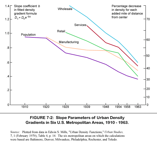
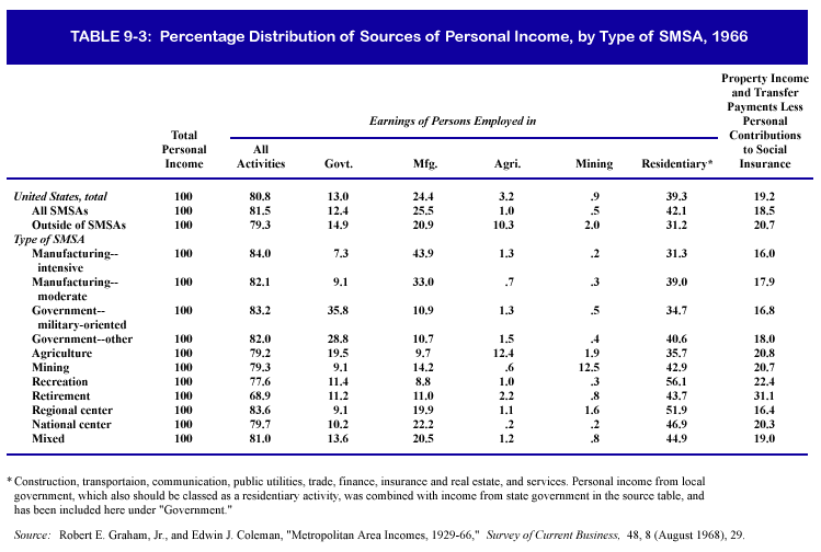
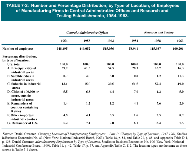