|
6.1 WHAT IS "LAND"?
In Chapter 4, competition for scarce local inputs
was identified as one of the factors limiting spatial concentration and
favoring the dispersal of activities. We are now ready to see how this
works.
The present
chapter deals with the dispersive effects of competition for land, which
first and foremost denotes space. Every human activity requires some elbowroom.
The qualities of land include, in addition, such attributes as the topographic,
structural, agricultural, and mineral properties of the site; the climate; the
availability of clean air and water; and finally, a host of immediate
environmental characteristics such as quiet, privacy, aesthetic appearance, and
so on. All these things—plus the availability of such local inputs as
labor supply and community services, the availability of transferable inputs,
and the accessibility of markets—enter into the judgment of what a
particular site is worth for any specific use.
Labor, as a
local input will be discussed in Chapter 10. The
present chapter focuses almost entirely on space per se as the prototype of
scarce local input. But it is appropriate to keep in mind that in an
increasingly populous and urban economy, more and more of what were initially
the free gifts of nature (such as water, clean air, and privacy) are assuming
the character of scarce local resources, and this scarcity constrains the
concentration of activities in somewhat the same way as does the inherent
scarcity of space itself. Competition for space in an urban area is highly
complex because of the many ways in which an activity affects its close
neighbors. Such neighborhood effects or local externalities were
touched on in Chapter 5 and will be further
explored in Chapter 7 as basic features of the
urban environment.
6.2 COMPETITION FOR THE USE OF LAND
Most land can be utilized
by any of several activities. Even an uninhabitable and impassable swamp may
have to be allocated between the competing claims of those who want to drain or
fill it and those who want to preserve it as a wetland wildlife sanctuary. The
normal multiplicity of possible uses means that in considering spatial patterns
of land use, we can no longer think in terms of the individual location unit
(as in Chapter 2) or of one specific activity (as
in Chapters 4 and 5) but must move up to another level of analysis:
that of the multiactivity area or region.
Competition
for land plays an important locational role in areas where activities tend to
concentrate for any reason. Locations having good soil, climate, and access to
other areas, and areas suitable for agglomeration under the influence of local
external economies, as discussed in Chapter 5,
are in demand. The price of land, which is our best measure of the intensity of
demand and competition for land, varies with quality and access, and rises
abruptly to high peaks in the urban areas. Anything we can discover about the
locational role of land-use competition, then, has particular relevance to the
urban and intraurban problems that have become so important in recent
years.
On the
other hand, there are activities that need large expanses of land in relation
to value of output and are, at the same time, sensitive to transfer cost
considerations—agriculture being the most important, though the same
considerations apply to forestry and some types of outdoor recreation as well.
These activities require so much space that although they do not effectively
compete for urban land, their location patterns are strongly affected by
competitive uses. Such activities are a second important area of application
for land-use analysis.
In
societies in which land use is governed through a price system, the price of
using land is identified as rent,1 and in
principle each parcel of land goes to the highest bidder. Owners of the land
will, if they want to maximize their economic welfare, see to it that the land
goes to that activity and specific "occupant" (firm, household, public agency,
or other) that will pay a higher rent than any other. At the same time,
occupants will ideally compare different sites on the basis of how much rent
they could afford to pay for each if it were utilized in the most efficient way
available to them, and will look for the site where the rent they could afford
to pay exceeds by the largest possible margin what is charged.
Needless to
say, land markets are not in fact so perfect in their allocation, nor are
owners or users possessed of omniscience or exclusive devotion to the profit
motive.
It is
almost equally obvious that allocation of the land based purely on individual
profit maximization, even if competition worked more efficiently than it does,
could not produce a socially optimum pattern of land use—not even in the
sense of maximizing the gross national product, to say nothing of more
comprehensive criteria of welfare. Here, as in every other area of economics,
some social intervention is required to take account of a wide range of costs
and benefits that the existing price system ignores. Just because a paper mill
can outbid any other user for a riverside site, it does not follow that it is
socially or economically desirable that it should preempt the river from other
users who would refrain from befouling it. Direct controls on land use
(including zoning ordinances, urban renewal subsidies, and condemnation or
reservation of land for public use) are vital elements of rational public
policy even where free competition is most enthusiastically
espoused.
Socialist
countries initially nationalized all land and attempted to assign it without
using any system of market or imputed prices. A retreat from this doctrinaire
position has been in evidence in recent years in some of these countries
(notably Yugoslavia), with competitive market forces being given an increasing
role in land-use allocation, though severe constraints prevail as to the amount
of land any one individual may own.
In 1966,
four Soviet legal experts pointed out the economic waste involved in allocating
land without explicit regard to its productivity in alternative uses. In a
striking departure from orthodox Soviet doctrine, they proposed "that we speed
the introduction of a land registry, which would incorporate the registering of
land use, a record of the quantity and quality of land, and an appraisal of its
economic value." They proposed, further, that the price of land be included in
cost estimates of construction projects. "Only thus will a true picture of
economies in construction become apparent. Let the economists work out the
form, but it seems to us that the attitude that land costs nothing must be
decisively rejected."2
Despite the
fact that Soviet planners had even earlier adopted the practice of including an
interest charge on plant and equipment in evaluation projects, the guardians of
Marxist orthodoxy have apparently thus far balked at using a price system to
guide land use, or even setting any quantitative value on land. A 1968
statement of land-allocation policy in the U.S.S.R. explicitly rejected land
pricing in these terms: Use of the land free of charge is one of the greatest
achievements of the Great October Socialist Revolution."3
The difficulties involved
in maintaining such a policy are extensive. Kenneth R. Cray has pointed out
that in the absence of an explicit assignment of land rents in the Soviet
Union, agricultural procurement prices paid by the state have been used as the
main mechanism by which land rents can be extracted; instead of charging rents
directly, to some extent rents are recovered by differentiation of official
purchase prices. Thus prices paid to farms in different regions for identical
products may vary substantially.4
Still
another situation applies in many less developed countries. A few large
landowners own the bulk of the land and have been able to stave off or subvert
any efforts to achieve land reform. The adverse effects of this concentration
of ownership would be far less if the owners were primarily concerned with
maximizing returns from use of the land. But they have generally been either
inert in the face of such economic opportunities or convinced that their
long-term interests are better served by blocking the industrial and political
changes that might follow a breakup of the static feudal order in which they
attained their positions.
In order to
understand the way in which land is allocated to various activities, we shall
first ask what determines how strong a bid any particular activity can make for
the use of land—that is, the maximum rent per acre that that activity
could pay for land in various locations. In a society that uses prices, costs,
and profits as a principal mechanism for allocating resources, this line of
inquiry will help explain actual location patterns. It will also provide a
rough guide as to which location patterns represent an efficient allocation of
resources from the standpoint of the economy as a whole. Later (particularly in Chapters 7 and 13), we shall give more explicit attention to
the important problem of divergences between individual interests and the
general public interest.
6.3 AN ACTIVITY’S DEMAND FOR LAND: RENT GRADIENTS AND RENT
SURFACES
There are
countless reasons why an individual, firm, or institution will pay more for one
site than for another. A site may be highly desirable because of its mineral
resources, soil quality, water supply, climate, topography, agreeable
surroundings, good input-output access (that is, access from input
sources and to markets), supply of labor, supply of public services, prestige,
and so on. In fact, the number of possible reasons for offering more for one
site than for another is equal to the number of relevant location factors, less
one (the price of the site).
For any
particular activity, or kind of land use, there is a geographical pattern of
site preference, represented by the amounts that practitioners of that activity
would be willing to pay or "bid" for the use of each of the various sites. If
we picture such a pattern, with the activity’s bid rent (or rent
bid) represented by height, we have a rent surface, with various
hollows at the less useful sites and peaks at the more useful sites. A cross
section of this surface, representing rent bids for sites along a specific
route, is called a rent gradient. The rent surfaces and gradients will
vary in their conformation according to the type of land use, and we shall see
later how space can be allocated among alternative uses on the basis of their
bids.
First,
however, it will be useful to see a bit more clearly how an individual
user’s pattern of rent bids arises. For this purpose, we shall consider a
particularly simple kind of situation, in which site desirability reflects just
the one location factor of access to a single given market. We shall
ignore, for the time being, all other distinguishing features of sites. The
sites being compared are all within the supply area of a single market center:
For example, they might be dairy-farm sites constituting an urban milkshed. For
still greater simplification, we shall assume that there are so many individual
producers in this supply area that each must take the market price as given in
deciding about his or her own output and locational preference.
6.3.1 Rent Gradients and Surfaces with Output
Orientation
Figure 6-1 shows a plausible relationship between the
various possible amounts of a particular kind of output on an acre of land and
the cost of the inputs (other than the land itself) required to produce that
output. There are some fixed costs (F), and some variable costs, which
rise more and more rapidly as the intensity of use approaches its feasible
maximum. Total costs are as shown by TC, and in symbolic
terms,
TC=F+aQb
where b is some exponent larger than 1. The average unit cost curve, AC, is
of the familiar U shape. Figure 6-1 is drawn with F =100, a =1, and b =3.
It hardly
needs to be said that the cost/output formula offered here is purely
illustrative, not based on specific empirical investigation. The formula does,
however, conform to generally accepted norms for the shape of production
functions.5
The total
cost (TC) curve of Figure 6-1 reappears in Figure 6-2, where we discern how the user of the site
can rationally determine the output per acre that will maximize his or her
rent-paying ability. The three white lines show receipts at three possible net
prices for the output at this site. They rise proportionately to output, since
we are assuming that the demand for the output of this producer is perfectly
elastic. This is generally the case in agricultural or other activities
involving many relatively small sellers.
At the
highest of the three prices, which might reflect a location rather close to the
market, the receipts curve (total revenue minus transfer costs on the output)
is OL and the largest surplus of receipts over nonland costs is BC, with an output of OA. Accordingly, BC represents the maximum
rent that this activity could afford to pay for the use of this acre. It will
be noted that at point C, the total cost curve, TC, has the same slope as the total receipts curve at that rate of output. In other
words, at that rate of output, marginal costs are equal to marginal receipts,
or price, and therefore the excess of revenues over costs is maximized (or
losses are minimized). Because the total cost curve includes the opportunity
cost of capital; that is, a "fair" return on capital, BC represents potential excess, or economic profits. For rent payments less than BC, economic profits will be realized, but the land user would be
willing to bid up to BC for rent at this location, recognizing that he
or she could still earn normal profits with this rental payment.
At a
location more remote from markets, the receipts curve will be OM, reflecting a lower net price because of higher transfer costs. In that
situation, the best rate of output is again the one for which the receipts and
cost curves have the same slope; but here, the maximum rent-paying potential of
the acre (the bid rent of this activity) is zero. At any rate of output smaller
or larger than OE, the land user could not cover costs even on rent-free
land, and this acre will consequently be worth precisely zero to him or
her.
At a less
advantageous location, where the net price is still lower (receipts curve ON), there is no rate of output that would cover costs, to say nothing
of providing anything for rent. The minimum subsidy, or negative rent, required
to make it worthwhile for this activity to use the land would be HJ, at
an output of 0G. Once again, this is the output at which the receipts
and cost curves are parallel.
Let us
assume, then, that our land user acts rationally and so adjusts the intensity
of his or her land use and the output per acre as to maximize the excess of
receipts per acre over costs exclusive of rent, and that this excess represents
the most he or she would bid as a rent payment for the acre.6
Now let us
compare the situation at sites located at different distances from a market, as
in Figure 6-3. At each site, the net price received
per unit of output is reduced by the costs of transfer to market. It will be
observed that the curve showing rent in relation to net price, in the upper
panel of the figure, is concave upward—in other words, the rent falls more
rapidly near the market and more gradually farther out. This characteristic
feature of rent gradients reflects the fact that we have allowed for some
flexibility in the intensity of land use in this activity. Output per acre is
larger at locations close to the market. The reason for this is that land rents
increase for locations closer to the market, and this implies that the price of
land will be rising relative to the price of other factors of production as
distance to the market diminishes, other things being equal. As this happens,
we should expect more intensive use of land; more of the other factors
of production will be used per acre of land, and output per acre will increase.
This means that the revenue per acre, and therefore the rent that can be
earned, is more sensitive to transfer cost at such nearby locations than at
more remote locations where a smaller amount of output is shipped from each
acre. Of course, if there were complete flexibility in intensity (that is,
immunity from diminishing returns), all of the activity could best be
concentrated in a single skyscraper at the market. The rent gradient would be
almost vertical.
The lower
panel of Figure 6-3 shows the same rent gradient, but
this time charted in relation to distance from the market. Because of
the characteristic economies of long-haul transfer discussed in Chapter 3, the net price of the product will
fall more and more slowly with increasing distance: Each extra dollar per ton
buys more and more extra miles of transfer as we go farther from the market.
Consequently, we can expect rent as a function of distance to have the
accentuated concavity shown in the figure.7
Over a
geographic area, we have a rent surface whose basic shape is a concave-sloped
"cone" with its peak at the location of highest possible rent; in the cases
discussed so far, that peak is at the market.
But for a
number of reasons, real rent gradients and surfaces are never so smooth and
regular as our diagrams suggest. In the first place, we have been assuming
throughout that all the land is of equal quality for this particular kind of
use, in all respects save access to market. A location or zone of locations
with some superior advantages (for instance, higher soil fertility or cheaper
labor) would be marked by a hump on the rent surface, and a place with higher
costs by a dent (or even a complete gap in the surface if for some reason that
activity could not be practiced there at all). The rather common stepwise
variation of transfer rates produces a corresponding terracing of rent
surfaces. Rent gradients will be flatter along routes of cheaper or better
transfer; so if we think of a rent surface around a market as a mountain, it
will fall away in sloping ridges along such routes and more abruptly elsewhere.
Finally, there is usually more than just one market; thus the rent surface of
an activity over any sizable area will rise to a number of separate
peaks.
6.3.2 Rent Gradients and Rent Surfaces with Input
Orientation
One may
well ask at this point why the theory of land use places so much stress on
access to markets. Why not access to the sources of transferable inputs? In
such a case, of course, we should have rent gradients and rent surfaces peaking
at such sources, rather than at markets.
Such
patterns do occur. Residents (particularly in resort areas but to some extent
elsewhere too) have a tendency to cluster around certain foci of consumer
attraction, such as beaches. The activity here is residence, which requires
space for which it is willing to bid rent. The input is enjoyment of the beach,
which is more easily available the shorter the distance. The intensity of land
use is measured by the degree of crowding of residents (persons per acre). In
addition, we observe characteristic gradients of intensity and rent. If there
are no considerations of desirability except access to the beach, and if the
residents are not too unlike in incomes and tastes, the land values will be
lower and the lot sizes larger the greater the distance from the beach. If the
beach is a long one, equally attractive throughout its length, the rent surface
will rise not to a peak but to a ridge or cliff along the shore, falling away
to landward.
We should
expect to find an analogous situation in an urban external-economy activity if
the principal attraction of a cluster lies in better access to production
inputs, such as supplies and services. A location in the center of such a
cluster is more valuable than one on the periphery.
By and
large, however, rent gradients are much more often focused around markets than
around input sources. The great space-using activities are agriculture,
forestry, and livestock grazing. They produce bulky transported outputs but
require relatively insignificant amounts of transported inputs; consequently,
their transfer orientation is overwhelmingly toward markets. The basic reason
for this is that their main inputs are nontransferable ones: solar
energy, water, and organic properties of the soil. They have a large stake in
being close to markets but a very small stake in being close to sources of any
transferable input, such as fertilizer or pesticide factories.
On the
urban scene, the greatest land-using activity is residence, and the transfer
orientation of residences is mainly toward markets for labor services; that is,
toward employment locations. Only a household consisting wholly of consumers,
without any members employed outside, is free to orient itself exclusively to
amenity "inputs." And even in cities known as recreation or retirement centers,
the great majority of households contain at least one worker. Although within
urban areas we do see neighborhood rent gradients rising toward parks or other
amenity locations, the overall pattern of rents and land values appears to be
shaped to a greater extent by access to jobs. High densities of urban
population occur almost exclusively in areas close to major job
concentrations.8
The various
business and government activities of an urban area, insofar as they serve the
local market, are strongly market-oriented because their transferable outputs
are so much more perishable and valuable than their transferable inputs.
Consequently, they have a large stake in access to the distribution of
residences, jobs, or both. Once again, we have rent gradients rising in the
direction of markets; in this case, generally toward the center of the urban
concentration.
Finally,
manufacturing industries oriented toward sources of transferable inputs are
mainly those engaged in the first-stage processing of rural products (crops,
including timber, and minerals). They are input-oriented, as noted in Chapter 2, because their processes
characteristically reduce weight and bulk, and sometimes (as in the case of
canning and preserving operations) perishability as well. But these processing
activities themselves are not extensive land users in a rural context. In fact,
they are highly concentrated relative to their suppliers, and they have supply
areas rather than being part of market areas. Consequently, their locations are
not significantly affected by land costs; but each of the units of such a
primary processing activity may represent a peak in the rent surface of the
activity supplying it with inputs.
The
foregoing discussion has justified the application of the rent gradient and
rent surface concepts primarily to output-oriented activities, with the
gradients and surfaces rising as we approach the market for the activity’s
transferable output.
6.3.3 Rent Gradients and Multiple Access
It is best
to keep in mind that a land user’s willingness to pay rent for the use of
a site need not depend solely on that site’s access to some single
point.
The pure
supply-areas case identified in Chapter 4 conforms most nearly to that situation. Each market is served by many scattered
sellers, and each seller disposes of its entire output in just one market.
Rural land uses, and in particular agriculture, are the classic example. The
multiplicity of sellers sharing the same market, moreover, implies relatively
pure competition. Any one seller’s output is small compared to the total
purchases of any one market; thus it has a perfectly elastic demand for its
output and can sell as much as it chooses to produce without affecting the
price.
As has
already been suggested, however, real-life situations are often more complex.
Specifically, the access advantages of a location may depend upon nearness to
more than one other point. Even small producers, particularly if their outputs
are not completely standardized, may sell to more than one market. In addition,
with respect to other kinds of access also—for example, supply of
transported inputs or labor, or the serving of customers who are themselves
mobile, such as retail shoppers—the true access advantage of a location is
often a composite reflecting transfer costs to a number of points. In such a
situation, the rent surface may well have a number of peaks, hollows, and
ridges, and may even peak at points of maximum access potential that are
intermediate between actual centers.
6.4 INTERACTIVITY COMPETITION FOR SPACE
Although we
have explained why any one activity can afford to pay a higher price for land
in some locations (primarily, closer to market), and why that activity’s
intensity of land use shows a similar spatial pattern of variation, nothing has
been said yet about land requirements as a factor influencing the relative
locations of different activities.
If we
consider a number of different activities, all locationally oriented toward a
common market point, a comparison of their respective rent gradients or rent
surfaces will indicate which activity will win out in the competition for each
location.
6.4.1 A Basic Sequence of Rural Land Uses
The
foundations for a systematic understanding of the principles of land use were
laid more than a century and a half ago by a scientifically minded North German
estate owner named Johann Heinrich von Thünen.9 He set himself the problem of how to determine the most
efficient spatial layout of the various crops and other land uses on his
estate, and in the process developed a more general model or theory of how
rural land uses should be arranged around a market town. The basic principle
was that each piece of land should be devoted to the use in which it would
yield the highest rent.
In von
Thünen’s schematic model, he assumed that the land was a uniform flat
plain (not too unrealistic for the part of the world where he farmed), equally
traversable in all directions. Consequently, the various land uses could be
expected to occupy a series of concentric ring-shaped zones surrounding the
market town, and the essential question was the most economical ordering of the
zones.
A set of
rent gradients for three different land uses, extending in both directions from
a market, is shown in the upper part of Figure 6-4;
and in the lower part of the figure this arrangement is translated into a map
of the resulting pattern of concentric land-use zones. Each land use (activity)
occupies the zone in which it can pay a higher rent than any of the other
activities. In the case shown, it appears that the land nearest the market town
should be devoted to forestry, the next zone outward to wheat, and the
outermost zone to grazing. The land beyond the pasturage zone would not have
any value at all in agricultural uses to supply this market town.10
The
gradient of actual land rents and land values in Figure
6-4 is the black line following the uppermost individual-crop gradient in
each zone. Such a composite gradient will necessarily be strongly concave
upward, since the land uses with the steeper gradients get the inner locations,
and the gradients are flatter and flatter for land uses located successively
farther out.
Finally, we
may note that this solution of the crop location problem can be applied
regardless of whether (1) one individual owns and farms all the land, seeking
maximum returns; (2) one individual owns all the land but rents it out to
tenant farmers, charging the highest rents he or she can get; or (3) there are
many independent landowners and farmers, each seeking his or her own advantage.
In a perfectly competitive equilibrium, the rent going to landowners and the
value of land would be maximized, and rents would be set at the maximum that
any user could afford to pay; as a result, landowners and tenants could all be
indifferent as to which zone they occupied, since the rate of return on capital
and labor would be the same in all of the zones used.
6.4.2 Activity Characteristics Determining Access Priority and
Location
In von
Thünen’s basic model (which assumes that each crop has the same
delivered price and transfer rate, and a fixed intensity of land use regardless
of location or rent), the rule for determining the position of a particular
land use in the sequence is a simple one. The activity with the largest amount of output per acre has the steepest rent gradient and is located
closest to the market, and the other activities follow according to their rank
in per-acre output.
The
situation is not quite so simple, however, when we recognize that land-use
intensity and output per acre can vary for any given activity; that the outputs
of the different activities are transferred at different rates of transfer cost
per ton-mile; and that the rent gradients themselves are characteristically
curved rather than straight, so that conceivably any two of them might
intersect twice rather than just once. Accordingly, we need to look more
closely into what characteristics of the various activities determine their
location sequence in relation to the market.
The
question can be posed as follows: If the rent gradients for two different
activities intersect (that is, they have the same rent level at some given
distance from market), and if we know something about the characteristics of
these two activities, what can we say about which activity is likely to have
the steeper gradient at the point of intersection and, consequently, the
land-use zone closer to the market?
It was
suggested earlier that a reasonable form of cost function for any one of the
activities is
TC=F +
aQb
where TC is the cost of nonland inputs on an acre, F the fixed cost per acre,
and Q the output of the acre; a and b are coefficients
characterizing the technology of the activity. More specifically, a large value
for a means that variable-cost outlays are high relative to output
and to fixed costs; a large b value means that variable costs per
unit of output rise rapidly with increased intensity (i.e., as more
variable inputs are applied to a fixed amount of land) because of the law of
diminishing returns (see footnote 5).
According
to this formulation of the relationship between output per acre and nonland
costs per acre, the rent gradient for the activity is, as shown in Appendix 6-1,
R = a(b — 1)[(P — tx)Iab] b/(b-1) — F
where R is the maximum rent payable per acre, P is the unit price of the
activity’s output at the market, t is the transfer charge per unit
of output per unit distance, and x is the distance to the
market.
Each of the
various identifying characteristics of an activity (a, b, F, and t) affects the shape and slope of the rent gradient in some way; and from that
effect we can surmise how each of these characteristics affects the likelihood
of the activity’s being a prime candidate for the occupancy of land near
the market.
The effects
are shown in Figure 6-5 in a series of four diagrams
(see Appendix 6-1) for explanation of the underlying
calculations and a proof of the general validity of the relationship shown). In
the first panel (upper left), we have intersecting rent gradients for two
activities that differ only with respect to the value of a in their
production functions (i.e., all other factors influencing the slope of the rent
gradient are held constant). The steeper gradient (implying location in the
inner zone) is that of the activity with the smaller a; that is, the
activity in which a given outlay per acre yields a larger amount of product.
This makes sense, since such an activity could be expected to have a larger
stake in proximity to markets than an activity producing small amounts of
transported outputs per acre.
The upper
right panel in Figure 6-5 shows, in like fashion, the
locational effect of the b coefficient—which, as mentioned above,
measures the strength of diminishing returns to the more intensive use of land.
The steeper gradient is that of the activity with the smaller b (in
other words, the activity with the greater flexibility in intensity, permitting
higher intensities nearer the market).11 For
example, activities able to use high-rise buildings can generally bid more for
central city land than can activities that must have a one-story
layout.
The lower
left panel indicates that higher fixed costs per acre are associated
with steeper gradients and close-in locations. When a large proportion of costs
are fixed, regardless of output per acre, the rise in unit variable costs with
higher intensity has less effect on rent-paying ability.
The
locational effect of differences in transfer rates is shown in the last panel
of Figure 6-5. As expected, an activity whose product
is bulky, perishable, valuable, or for any other reason expensive to
transfer has an especially strong market orientation and can pay a high
premium for locations near its market.
Thus transfer and production characteristics help to determine the
ability of an activity to bid for locations at various distances from the
market center. The savings in transfer costs associated with more central
locations depends crucially on two factors: (1) the quantity of transported
output produced for a given total outlay and (2) the transfer rate per unit of
output. Production cost advantages accrue at more central locations to those
activities that (1) can use land more intensively and (2) have higher fixed
costs per acre.
6.5 RURAL AND URBAN LAND USE ALLOCATION
The general
principles of land-use competition and location of space-using activities that
we have developed thus far are relevant to the highly extensive rural land uses
to which this theory was originally addressed and also to the relatively
microscale land-use patterns within urban areas. These principles can also be
used to explain how land is allocated between rural and urban
uses.
In order to
appreciate how these principles may be applied in a rural/urban context, it is
only necessary to realize that the activities which compose an urban area have
assumed relatively central locations because they have been successful in
bidding that land away from competing uses. As in the preceding discussion of
land-use competition among rural activities, our explanation of this outcome
rests on identifying the transfer and production characteristics
that cause urban land users to place high value on access
considerations.
6.5.1 Some Characteristics of Urban Economic
Activity
One special
feature of activity in urban areas is the important role played by the movement of people and the necessity of direct and regular face-to-face contact in location decisions. A crucial function of cities
is to enable large numbers of people to make contact easily and
frequently—for work, consultation, buying and selling, negotiation,
instruction, and other purposes. People are more expensive to transport than
almost anything else, mainly because their time is so valuable. Accordingly,
intracity locations are governed by powerful linkage attractions operating over
short distances and emphasizing speed of travel.
Another
feature of urban locations is the intense interdependence caused by
proximity and by competition for space and other nontransferable inputs. Every
activity affects many neighbors, for better or for worse: External economies
and diseconomies are always strong.
Both of
these features imply that the advantage of physical proximity, as measured by
money and time saved, is of the utmost importance to many types of economic
activity within urban areas. The primary function of an urban concentration is
to facilitate access, and time costs are a major determinant of access
advantage in the urban setting.
Access
linkages among nonresidential activity units involve in part interindustry transactions.12 Thus business
firms have an incentive to locate with good access to their local suppliers and
their local business customers. Some important interbusiness linkages, however,
do not directly involve such transactions at all. Local branch offices or
outlets of a firm are presumably located with an eye to maintaining good access
to the main local office, while at the same time avoiding overlap of the
sublocal territories served by the branches (for example, the individual
supermarkets of a chain or branch offices of a bank). There are strong access
ties between the central office of a corporation and its main research
laboratory, involving the frequent going and coming of highly paid personnel.
Additionally, as we saw in Chapter 5, substantial
economic advantages can accrue to some activities as a result of clustering.
The nature of these agglomeration economies most often depends on close
proximity.
Linkages among households are also important. A significant proportion of
journeys from homes are to the homes of others. Such trips are by nature almost
exclusively social and thus involve people linked by family ties or by similar
tastes and interests. This observation suggests that the value of
interhousehold access can also be expressed fairly accurately in terms of a
preference for homogeneity. However, the pressures toward neighborhood
homogeneity include other factors besides access.
Linkages between residential and nonresidential units are by far the most
conspicuous. The entire labor force, with minor exceptions, is concerned with
making the daily journey to work as quick and painless as possible, and work
trips are the largest single class of personal journeys within an urban
area.13 Shopping trips are another major category.
The distribution of goods and services at retail makes mutual proximity an
advantage for both the distributors and the customers. Trips to school and
cultural and recreational trips make up most of the rest of the personal trip
pattern. There is mutual advantage of proximity throughout. The nonresidential
activities dealing with households are most advantageously placed when they are
close to concentrations of population, and at the same time residential sites
are preferred (other things being equal) when they provide convenient access to
jobs, shopping districts, schools, and other destinations.
Thus
interdependence, the importance of the movement of people, and the necessity of
direct contact is significant characteristics of urban activity. Individually
they suggest the crucial role played by transfer considerations in shaping
urban land use decisions. Jointly, these characteristics have a substantial
effect on the urban rent gradient.
As
described in the preceding section of this chapter, transfer factors affect the
steepness of rent gradients in two ways: Higher transfer rates per unit
distance and greater quantities of output for a given total outlay both make
movements away from central locations costly. Thus activities with these
characteristics are willing to bid high rents for locations with access, and
their bid rents fall rapidly as distance from the center increases.
For urban
activities, transfer factors of this type are very important in locational
decisions. The increased expenses associated with maintaining contacts and
developing new ones at longer distances, as well as the lost time associated
with the movement of people, are important considerations in locational
decisions. Their significance is reflected in higher rent bids for locations
with good access.
While it is
easiest to think of output as measured in physical units (e.g., tons of steel
or the number of customers served), many types of output are not so easily
described. Financial or consulting services are cases in point; output measures
are much less tangible in these activities. However, in some instances the
frequency of personal contact is itself indicative of the rate of output.
Therefore, urban land users, particularly service industries, are often not
only characterized as having higher transfer rates (primarily time costs
associated with the movement of people), but they may also have high rates of
output (entailing many interpersonal contacts) for a given total
outlay.
In addition
to these transfer considerations, our earlier discussion concerning the
activity characteristics determining access priority suggests that production
factors may also help to explain the high value placed on central locations by
urban activities. In particular, the ability to substitute easily between
nonland and land inputs contributes substantially to the steepness of the urban
rent gradient. Thus activities that are able to use high-rise buildings (e.g.,
insurance companies or corporate headquarters) can bid more for central city
land than can activities that must have a one-story layout. Further, to the
extent that substitutions imply more of such fixed costs as buildings and
equipment per acre of land, the steepness of urban rent gradients is also
enhanced.
The
provision of downtown off-street parking for cars provides an interesting
example of the relevance of both transfer and production advantages on urban
land use. Parking services are oriented toward the destination of car users
after they leave their cars, since they will be making the rest of the journey
on foot. In a parking lot, the nonrent costs are mainly the wages of an
attendant, although there may be some capital outlay associated with the
attendant’s hut or an automatic gate mechanism. Also, the capacity of the
lot has a definite limit. Here, then, we have an activity with a high transfer
rate, low fixed costs, and a very limited ability to substitute nonland for
land inputs. A multilevel parking garage has the same transfer rate but
fairly high fixed costs, since there is now a substantial investment in a
structure. Additionally, the garage can use land much more intensively by
increasing the height of the building. Consequently, the parking garage will
have an even steeper rent gradient than a parking lot and will be the
predominant form of facility in areas where the demand for parking and the
demand for space in general are greatest.
6.5.2 Equilibrium of Land Uses and Rents
The
production and transfer characteristics of activities that occupy urban areas
thus enable them to use land intensively and to bid high rents for central
locations. We now have some explanation of the sequence in which we could
expect different activities to arrange themselves around a common focal point,
such as a market or central business district. However, we have yet to examine
the factors that contribute to the width of an activity’s zone, and
consequently our analysis of factors that might affect the allocation of land
among uses is incomplete.
Since we
are still assuming that land is of equal quality everywhere, the greater the
demand for an activity, the larger the zone it will occupy. Thus we might think
of an urban area as comprising the zones of a number of activities. If the
market demand associated with one such activity increases, its bid rents will
also increase. Figure 6-6 depicts an activity’s
net receipts (total revenue minus transfer costs on the output), NR, and
total cost (exclusive of rent), TC, at a given distance from the
city center. An increase in demand may result in an increase in that
activity’s equilibrium price, and therefore, it would rotate NR to NR’. As a consequence, equilibrium output per acre would increase
from 0A to 0A’ (land would be used more intensively), and
bid rents would be larger. In this example, the maximum rent that can be paid
at this distance from the center increases from BC to B’C’.
The initial
effect on the zone occupied by this activity is demonstrated in Figure 6-7. Here, the rent gradients associated with
three different activities are presented. We might think of the first, with
gradient aa, as being central office functions. The second and third,
with gradients bb and cc, might represent light manufacturing and
agriculture respectively.
Suppose
that the manufacturing sector experiences an increase in demand. As explained
above, it may now bid higher rents at any given distance from the market
center, and its rent gradient will, therefore, shift upward to b’b’. The zone occupied by this activity widens, encroaching
on each of the others. Note that the increase in demand has two immediate
effects: (1) the extension of the manufacturing zone, and (2) the more intensive use of land. The increase in demand has elicited a supply
response as the market allocates more resources to this activity. In our
example, not only are other urban land uses affected, but the conversion of
rural agricultural land also takes place.
Other
effects are possible. For example, as the area occupied by agricultural
activity becomes smaller, the supply of output from that sector diminishes.
Also, the expansion of urban activity may cause an increase in demand for
agricultural goods or central office services. The forces of supply and demand
come into play once again. As new, higher equilibrium prices are established in
these sectors, new rent bids can be made, forcing changes in each activity
zone. Higher prices and rents result in all sectors, with greater intensity of
land use in each.14
This kind
of adjustment goes on all the time in the real world. In transition
neighborhoods in cities, we see old dwellings and small stores being demolished
to make way for office buildings and parking garages; old mansions being
subdivided into apartments, replaced by apartment buildings, or converted to
funeral homes; and in the suburbs, farmlands and golf courses yielding
themselves up to the subdivider.
Here, the
nature of the demand for land is most apparent. It is a derived demand,
reflecting the interplay of the demands for various activities as well as their
production and transfer characteristics. We find that the spatial distribution
of resources is an integral part of the market process.
6.6 RESIDENTIAL LOCATION
The
analysis of land use developed in this chapter views economic activities as
differing in the value that they place on access to some central location. As
indicated earlier, households are a major land-using activity, and they too are
characterized by significant access linkages. Because of this, some of the
principles developed thus far concerning land-use decisions are applicable to
residential location decisions.
One of the
first and most widely recognized efforts to explain residential location
behavior is that of William Alonso.15 Alonso
applies the concept of bid rent in order to isolate factors that contribute to
the household’s willingness to pay for access to the central business
district (CBD) of an urban area. Bid rents have been defined as the maximum
rent that could be paid for an acre of land at a given distance from the market
center, if the activity in question is to make normal profits. Here, however,
we want to analyze residential location behavior, so the concept of
profits is no longer relevant to the decision-making process. Instead, Alonso
recognizes that households make choices among alternative locations based on
the utility or satisfaction that they expect to realize. Consequently, the bid
rent of a household is defined as the maximum rent that can be paid for a unit
of land (e.g., per acre or per square foot) some distance from the city center,
if the household is to maintain a given level of utility.
Figure 6-8 presents several bid rent curves labeled u1, u2, and u3 for one household. Each of these curves plots the relationship between
rent bids and distance from the CBD associated with a different level of
utility. 16
These
curves have several important characteristics. First, they are negatively inclined. As developed earlier in this chapter, the rent gradient of a
particular activity plots out decreasing rent bids as distance from the market
increases because of transfer costs. Household rent bids are similarly affected
by transfer considerations. An individual facing a daily commute to the CBD for
work or shopping, or both, must pay lower rents in order to offset the
associated transfer costs of a longer trip, if utility is to be held constant.
Second, lower bid rent curves are associated with greater utility. Assuming that the household’s budget is fixed, at any given
distance from the CBD, if a lower rent bid is accepted, more other goods can be
consumed. Therefore, utility will increase. Finally, bid rent curves are single valued. This means that for a given distance from the CBD only
one rent bid is associated with each level of utility. By implication, we may
state that bid rent curves cannot intersect; otherwise they could not be single
valued.
The
gradient of actual rents in the city is given by R in Figure 6-8. As explained previously, this gradient
reflects the outcome of a bidding process by which land is allocated to
competing uses. From the household’s perspective, it provides information
on the rental cost of land that the household can evaluate, in light of its
preferences and budget, in order to choose a location more or less distant from
the city center.
When faced
with these rents, the decision makers in the household will prefer to reach the
lowest possible bid rent curve in order to maximize utility; thus, a residence
at location d2 would be chosen. Note that at any
more central location, the rent gradient (R) is steeper than any
intersecting bid rent curve such as u1. The rent
gradient offers information on the actual decrease in rents with greater
distance from the CBD, while the bid rent curves offer information on the
decision makers’ willingness to trade off more distant locations for lower
rents. Therefore, for any location to the left of d2, the
decrease in actual rents with increased distance is more than sufficient to
compensate the household for the greater commuting costs associated with living
farther out. A location such as d1 cannot be an
equilibrium location for this household: For any move away from the center,
actual land rents fall faster than the bid rents necessary to maintain the
utility level u1, and utility can therefore be
increased by such a move.
The
converse is true for locations to the right of d2. A constant
level of utility can be maintained if rent payments decrease at the rate given
by the bid rent curves. However, the rent structure of the city requires higher
rents for these locations; therefore, utility is decreased by a move to any
location more distant than d2.
Any factors
that might cause the slope of the bid rent curve to increase will draw the
household closer to the city center. The bid rent curves describe the
household’s willingness to give up access to central locations. If they
are steep, access is valued highly, and more remote locations will be accepted
only at very low rents.
It is
possible to isolate two factors that are important in determining the steepness
of a household’s bid rent curve. The first such factor is transfer
costs.17Higher transfer costs tend to
increase the slope of the household’s bid rent curve, and this tendency
draws the household closer to the CBD. If each move away from the center is
more costly in terms of commuting expenses, higher rent bids for close-in
locations are warranted. In considering this factor, one should keep in mind
that the opportunity (time) cost of commuting can be especially important in
evaluating the transfer costs of a household. If each hour spent on the road is
valued more, commuting becomes more dear, and rent bids fall more rapidly as
distance from the CBD increases.
The second
factor determining the steepness of the bid rent curve is the household’s demand for space. The larger the quantity of land occupied by the
household, the more it stands to gain in moving to the outlying location. As
rents fall per unit of land with increased distance from the CBD, the more
units that are occupied, the more total savings are realized by such a move. It
follows that bid rents will fall less rapidly with distance from the CBD if the
amount of land occupied is large: A smaller decrease in rent per unit of
land is required to compensate for the commuting costs associated with the
more distant location. This results in flatter bid rent curves, and
outlying locations are encouraged.
A number of
researchers have tried to use models similar to the one developed here in order
to analyze the consequences of higher income on residential location choice. In
this context, we find that an increase in income will have opposing effects on
the steepness of the bid rent curve. Transfer costs will certainly increase for
households with higher income as the opportunity cost of commuting increases.
By itself, this will tend to increase the slope of bid rent curves and should
encourage high-income households to live closer to the CBD. At the same time,
however, higher-income households are likely to demand more space, and
this will draw the household farther away from the CBD.
In American
cities, we often observe higher-income households living in suburban locations,
while lower-income households occupy more central locations. We shall have more
to say about this phenomenon in Chapter 7, where
the spatial structure of urban areas is examined in some depth; however, the
theory of residential location we have presented suggests that the income
elasticity of demand for space and the income elasticity of commuting costs may
be important factors underlying this spatial pattern.
Alonso does
not take into account the opportunity costs associated with commuting;
therefore, in his model the primary effect of higher incomes on bid rent curves
is through changes in the quantity of land demanded by the household. Since he
expects this quantity to increase with income, he argues that flatter bid rent
curves, higher incomes, and locations more distant from the CBD go hand in
hand.18
Richard
Muth, however, explicitly recognizes both of the factors that we have
identified as determining the slope of the bid rent curve. His analysis is
developed on the basis of the quantity of housing services consumed rather than
the quantity of land per so. In fact Muth’s model of residential location
decisions also differs in several other respects from that presented above, but
the factors underlying the income-location relationship are common to
both.
Muth points
out that the income elasticity of demand for housing has been empirically
estimated as exceeding 1 and possibly running as high as 2—in other words,
a 1 percent increase in income is associated with willingness to increase
expenditure on housing by more than 1 percent. By contrast, the effect
of additional income upon hourly commuting costs is almost certainly less than 1 to 1. This is so because the money costs of a given journey do not
depend on income at all, whereas the time costs may be assumed to vary roughly
in proportion to income. Consequently, higher income is associated with
increased willingness to sacrifice access for more spacious and better
housing.19
William C.
Wheaton has challenged the generality of this conclusion.20 He calculates income elasticities on the basis of a
sample of several thousand households in the San Francisco Bay area and finds
no support for Muth’s position. These data suggest that the income
elasticity of total travel costs in commuting and the income elasticity of
demand for land are about equal and therefore mutually offsetting in terms of
any effect on the bid rent curves. This result leads him to conclude that one
must look to other factors in order to explain the suburbanization of
America’s middle- and upper-income groups.
For
example, another important basis for these suburban preferences is a liking for
modernity as such. Dislike of old houses and neighborhoods (as well as
associated externalities) and a superior mobility may go far to explain the
generally positive association between income and suburbanization.
This
association is especially prominent in families with school-age children, who
are naturally more sensitive to differentials in school quality, neighborhood
amenity and safety, open space, and neighborhood homogeneity. An analysis of
residential patterns in the Greater New York area in the 1950s showed that
well-to-do families with children under the age of fifteen showed relatively
strong suburban and low-density preferences, while those without such children
were more willing to accept the higher densities of close-in communities.
Differences according to presence or absence of children were less evident for
lower-income families, whose latitude of choice of residential areas is
narrower.21
The
foregoing examination of the factors underlying urban residential patterns
serves also to remind us that we are not dealing here with any inexorable or
universal law of human behavior. Indeed, an inverse relationship between
income and distance from city center has prevailed in some other countries and
in other historical periods. In those situations, the wealthy favor inner-city
locations with good access, while the poor huddle in suburban shantytowns. Many
Latin American cities, such as Rio de Janeiro, illustrate this pattern;22 and in preindustrial America, the mansions of the rich
were generally found quite near the center of town.
6.7 RENT AND LAND VALUE
Our
discussion of rents and competition for land has placed almost exclusive
emphasis on the location of a site (relative to markets and sources of
inputs) as an index of its value. Location has determined how much rent any
particular activity can afford to pay for the use of a site; the purchase price
has been explained as simply the capitalized value of the expected stream of
future rents. At this point we need to recognize some significant complications
that have until now been ignored.
6.7.1 Speculative Value of Land
First, the
expected future returns on a parcel of land may sometimes be quite different
from current returns, particularly in locations where radical changes of use
are taking place or expected. This is generally true around the fringes of
urban areas, where the change involves conversion from farm to urban uses. The
price that anyone will pay for the current use of the land may be quite low in
relation to the speculative value based on a capitalization of expected returns
in a new use.
This point
is illustrated in the results of a study of agricultural land near the city of
Louisville, Kentucky, well over half a century ago (see
Table 6-1). It will be observed that in the zones farther than 8 or 9 miles
from the city, the current annual rent was consistently about 5 percent of the
average value of the land. In other words, the value was approximately 20
years’ rent at the current rate. Closer to the city, the land was worth,
on the average, well over 26 times the current annual rent; the capitalization
rate was only 3.8 percent. This obviously reflected the expectation that
returns on the nearby land would rise as the urbanized area spread.
Incidentally, the same table (Rows 1, 5) shows that the size of the
farm unit increased consistently with greater distance from the city in terms
of acreage but remained roughly constant in terms of total land rent. This is
consistent with the idea that the scale of the individual farm unit is
constrained by size-of-firm considerations involving management capability and
financial resources. The same study showed systematically greater inputs of
labor and fertilizer per acre and per farm nearer to the city.
6.7.2 Improvements on Land
A further
complication is that land is ordinarily priced, sold, and taxed in combination
with whatever buildings and other "improvements" have been erected on it, since
such structures are usually durable and difficult (if not impossible) to move.
On urban land, improvements may account for a major part of the value of the
parcel of real estate; and in all cases it is probably difficult to estimate
just how much of the price represents the value of space per se, or "site
value." Sometimes the "improvements" have a negative value: In other words, the
land would be more desirable if it were cleared of its obsolete
structures.
TABLE 6-1: Acreage, Rent per
Acre, and Value per Acre of Farms,
by Distance from Louisville,
Kentucky |
| |
Distance from Louisville (Miles) |
| |
8 or
Less |
9 to
11 |
12 to
14 |
15 or
More |
|
(1) Average acres
per farm |
102 |
221 |
256 |
257 |
|
(2) Land rent per
acre ($ per annum) |
11.85 |
5.59 |
5.37 |
4.66 |
|
(3) Land value per
acre ($) |
312 |
110 |
106 |
95 |
|
(4) Capitalization
rate (%) (2)1(3) |
3.8 |
5.1 |
5.1 |
4.9 |
|
(5) Rent per farm
per annum ($) (1) x (2) |
1210 |
1235 |
1430 |
1295 |
Source: J. H.
Arnold and Frank Montgomery, Influence of a City on Farming, Bulletin
678 (Washington, D.C.: U.S. Department of Agriculture,
1918).
Such
structural obsolescence is an important aspect of some of the most serious
problems confronting U.S. cities today. Moreover, the distinction between site
value and total real property value is crucial to an evaluation of the role of
the real property tax, which is the fiscal mainstay of local
governments.
6.8 SUMMARY
Competition
for space and other fixed local resources (collectively termed "land") plays an
important role in location, especially in urbanized areas and for activities
using much space relative to their outputs. In a free market, land goes to the
user who can bid the highest rent or price for it. Price represents a
capitalization of expected rents.
The way in
which any activity’s rent bids vary over an area (the rent surface) or
along a route (the rent gradient) depends on the local qualities of the sites
themselves, on their accessibility, and on other factors relevant to the
activity’s locational preferences. Rent gradients and surfaces for most
activities show peaks at market centers.
When
several activities are competing for space around some common market point, the
activities that preempt the land with the best access tend to be those that
have a large volume of output per unit of space used, those whose output bears
high transfer costs, and those least subject to rising operating costs with
increased intensity of land use (crowding).
The
production and transfer characteristics associated with activities in urban
areas cause them to place high value on locations with central access. The
location of these activities is especially affected by the need for movement of
people and direct personal contact, with time consequently playing the major
role in transfer costs and access advantage. Complex linkages among units and
activities, and competition for space, are also important location factors in
an urban context.
Access
considerations play an important role in residential location decisions. The
space occupied by a household and commuting costs (especially the opportunity
or time cost of commuting) affect its willingness to bid for land with good
access to central locations.
The demand
for land plays an important role in the market process and is affected by
changes in the demand for various activities that compete for its
use.
|
TECHNICAL TERMS INTRODUCED IN THIS CHAPTER |
|
Land |
Rent |
Intensity of land
use |
|
Neighborhood effects,
or local
externalities |
Rent bid, or bid
rent |
Central business
district (CBD) |
|
Region |
Rent
surface |
|
| |
Rent
gradient |
|
SELECTED READINGS
William
Alonso, Location and Land Use (Cambridge, Mass.: Harvard University
Press, 1964).
Edgar S.
Dunn, The Location of Agricultural Production (Gainesville: University
of Florida Press, 1954).
Johann
Heinrich von Thünen, Der isolirte Staat in Beziehung auf
Landwirthschaft und Nationalökonomie (1st volume published in 1826,
subsequent volumes published later); Carla M. Wartenberg (tr.), The Isolated
State (London: Pergamon Press, 1966).
William C.
Wheaton, "Income and Urban Residence: An Analysis of the Consumer Demand for
Location," American Economic Review, 67, 4 (September 1977),
620-631.
APPENDIX 6-1
Derivation of Formulas for
Rent Gradients and Their Slopes
Let the total cost of
production per acre (exclusive of rent) be
TC=F + aQ b (1)
where F is fixed
cost per acre, Q is output per acre, and b > 1. The bid rent,
or maximum rent per acre that could be paid, is
R=(P — tx) Q — aQb — F (2)
where P is the unit
price of the output at the market, t is the unit transfer cost per mile,
and x is the distance to market.
dR/dQ =P — tx — abQb-1 (3)
d2RIdQ2 =(1 — b) abQb-2 <
0 (4)
Since the second derivative
is negative because b > 1, setting the first derivative to zero will
give the output that maximizes R.
P — tx —
abQb-1=0 (5)
Q=[(P— tx)/ab]/1/(b-1) (6)
Substituting in (2), and
simplifying,
R=a(b — 1) [(P — tx)/ab]b/(b-1) —
F (7)
This is the rent gradient
with respect to distance from the market.
dR!dx=— t[(P — tx)Iab]1/(b-1) <
0 (8)
Therefore,
the rent gradient always slopes downward from the market.
d2RIdx2 = [t2/ab(b — 1)] [(P — tx)/ab](2~b)(b-1) >
0 (9)
By (9), the
rent gradient is always concave upward.
The
procedure followed in deriving the rent gradients shown in Figure 6-5, which indicate the effect of each of the
parameters on the slope, was as follows:
Since the
question as to which one of two activities takes the zone closer to market is
determined by the relative slopes of the two gradients at their point of
intersection, it is necessary to set the market prices at a level P* such that the gradients representing activities with different a, b, F, or t values will intersect. Let the coordinates (rent and distance
respectively) of the point of intersection be R* and x* (which were set
at 1,000 and 50 respectively in calculating the gradients plotted in Figure 6-5).
Then
R*=a(b—1)[(P* — tx*)/ab]b/(b-1) — F
and from
this,
(P* — tx*)!ab =[(R* + F)/a(b —1)](b-1)/b
Substituting in (8) gives
the slope (S*) at the intersection point:
S*=— t[(R* + F)/a(b — 1)]1/b
From this
it is clear that
- ¶ S*/¶ a > 0
- ¶S*/¶ b > 0
- ¶S*/¶ F < 0
- ¶S*/¶ t < 0
In other
words, if two activities have intersecting rent gradients and are alike with
respect to all but one of the four parameters a, b, F, t, the activity
with the steeper (more strongly negative) slope at their intersection will be
the activity with the lower a, or the lower b, or the higher F, or the higher t.
In
calculating the illustrative gradients shown in Figure
6-5, the following parameters were used:
| |
a |
b |
F |
t |
|
Standard case for
comparison, which appears in each of the four panels of Figure 6-5 |
10 |
2 |
100 |
1 |
|
Larger a |
20 |
2 |
100 |
1 |
|
Larger b |
10 |
4 |
100 |
1 |
|
Larger F |
10 |
2 |
500 |
1 |
|
Larger t |
10 |
2 |
100 |
2 |
ENDNOTES
1. Through
most of this discussion, we shall use the convenient term "rent" to indicate
the price for the use of a piece of land. If a new user buys the land instead
of renting it from an owner, the price he or she will have to pay represents a capitalization of the expected rents, at the expected rate of interest.
Thus if each of them expects to be able to get a 12 percent interest return on
capital invested in other ways, the buyer and the seller should agree on
$40,000 as a fair price for a piece of land that is expected to yield a net
rent (after all costs including property taxes) of $4,800 a year for the
foreseeable future. At that price, the returns will be 12 percent of the
investment.
2. The statement appeared in Pravda, 30 May 1966, and was
reported in the New York Times of that date, p. 12.
3. The quotation is from a set of draft principles of land
legislation submitted in a report by Deputy F. A. Surganov, Chairman of Council
of the U.S.S.R. Agricultural Committee. The report was published in Pravda and Izvestia, 14 December 1968, and in a condensed translation in
the Current Digest of the Soviet Press, 21, 1(22 January 1969),
12-20.
4. Kenneth R. Gray, "Soviet Agricultural Prices, Rent and Land
Cadastres," Journal of Cornparative Economics, 5, 1 (March 1981), 43-59.
We are indebted for this and the previously cited references on Soviet
land-rent policy to our colleague, Professor Janet G. Chapman.
5. In particular, it exhibits the effect of the law of diminishing
returns. Note that with b=1, TC would increase linearly with
output. For b > 1, the increase in TC is more than
proportional to increases in Q. As the rate of output is increased by
using more of some variable factor of production with all other inputs fixed,
the law of diminishing returns requires that at some point the marginal
productivity of that variable factor must decline. Declining productivity at
the margin implies increasing costs at the margin: Each unit of input is
capable of producing less additional output than preceding units, and therefore
the marginal costs of production rise. This characteristic of the relationship
between productivity and costs is reflected in the total cost formula used
here. As long as b > 1, the increment in total cost associated with
any increase in Q will be larger the larger Q itself is,
reflecting the diminished productivity of variable factors of production as the
rate of output is increased on a fixed parcel of land.
6. While the preceding analysis focuses on the effect of transfer
costs associated with the delivery of output to the market on the rent-paying
ability of an activity, any factor that affects receipts or costs at different
locations will also affect bid rent and land use.
7. Solow has constructed an interesting urban land-use model in which
traffic congestion is taken into account by making transport cost per ton-mile
depend on traffic density. He finds that the congestion factor makes the rent
gradient even more concave upward than it would otherwise be. Robert M. Solow,
"Congestion, Density, and the Use of Land in Transportation," Swedish
Journal of Economics, 74, 1 (March 1972), 161-173.
8. Unfortunately, this does not mean that the inhabitants of the
highest density areas in our cities necessarily enjoy adequate access to jobs,
despite being located near the center. The majority of urban poor persons live
in the central cities of metropolitan areas, and yet many of the jobs that they
can fill have tended to move to the suburbs. This and some related problems are
taken up later, in Chapter 13.
For an
interesting attempt to separate statistically the access and amenity components
of land value differentials, see R. N. S. Harris, G.S. Tolley, and C. Harrell,
"The Residence Site Choice," Review of Economics and Statistics, 50, 2
(May 1968), 241-247.
9. See selected readings in this chapter. A
thumbnail summary of the main ideas of von Thünen’s pioneer theory of
land uses appears in Martin Beckmann, Location Theory (New York: Random
House, 1968), Chapter 5.
Von
Thünen indulged in a convenient simplifying assumption to the effect that
any given activity (such as wheat growing) requires land in a fixed ratio to
the other inputs and the output. In other words, the intensity of land use
and yield per acre are fixed regardless of the relative prices of the land, the
other inputs, and the output. Although this assumption has often been retained
by later theorists, we are here trying for a little more realism by allowing
variation in intensity.
10. Von Thünen did indeed assign forestry to a
nearby zone as this illustration shows, which seems bizarre to us today. The
explanation is that in his time the woods supplied not only construction timber
but also firewood, a quite bulky necessity for the townspeople.
11. It may be noted here that the von Thünen
assumption of an unchangeable intensity of land use in any given activity is
most closely approached in our model if we have a very high b coefficient. The total cost curve (see Figure 6-1)
then looks almostû-shaped.
12. The nature of linkages among economic activities is
given detailed consideration in Chapters 9 and 11.
13. For relevant reference material, see John R. Meyer,
J. F. Kain, and M. Wohl, The Urban Transportation Problem (Cambridge,
Mass.: Harvard University Press, 1965); and Albert Rees and George P. Shultz, Workers and Wages in an Urban Labor Market (Chicago: University of
Chicago Press, 1970). Also, for a primarily bibliographical survey of the whole
question of access evaluation, see Gunnar Olsson, Distance and Human
Interaction: A Review and Bibliography, Bibliography Series, No. 2
(Philadelphia: Regional Science Research Institute, 1965).
14. A somewhat more rigorous analytical basis for this
type of analysis is offered in Richard Muth, "Economic Change and Rural-Urban
Land Conversion," Econometricia 29, 1 (January 1961), 1-23.
15. See William Alonso, Location and Land Use (Cambridge, Mass: Harvard University Press, 1964), for a full statement of
his early theoretical work on agricultural, business, and residential land
uses. For a concise nonmathematical presentation of his ideas on this topic,
see William Alonso, "A Theory of the Urban Land Market," Papers and
Proceedings of the Regional Science Association 6 (1960).
149-157.
16. Readers familiar with indifference curve mappings
will recognize that bid rent curves and indifference curves differ in important
ways. As Alonso puts it ("A Theory of the Urban Land Market," p. 155):
"Indifference curves map a path of indifference (equal satisfaction) between
combinations of quantities of two goods. Bid rent functions map an indifference
path between the price of one good (land) and quantities of another and strange
type of good, distance from the center of the city. Whereas indifference curves
refer only to tastes and not to a budget, in the case of households, bid rent
functions are derived from budget and taste considerations."
17. For an explanation of the effect of transfer costs
on the household’s bid rent using indifference curves, see Hugh 0. Nourse, Regional Economics (New York: McGraw-Hill, 1968), pp.
110-114.
18. See Alonso, Location and Land Use, pp.
106-109.
19. See Richard F. Muth, Cities and Housing: The
Spatial Pattern of Urban Residential Land Use (Chicago: University of
Chicago Press, 1969), pp. 29-34, for further details. He concludes that "on a
priori grounds alone the effect of income differences upon a household’s
optimal location cannot be predicted. Empirically, however, it seems likely
that increases in income would raise housing expenditures by relatively more
than marginal transport costs, so that higher-income CBD workers would live at
greater distances from the city center" (p. 8).
20. See William C. Wheaton, "Income and Urban Residence:
An Analysis of the Consumer Demand for Location," American Economic Review, 67, 4 (September 1977), 620-631.
21. E. M. Hoover and Raymond Vernon, Anatomy of a
Metropolis (Cambridge, Mass.: Harvard University Press, 1959), Table 41, p.
180. For an analysis of the locations of various types of families in Cleveland
in terms of distance from center, age, density, and industrial characteristics
of neighborhoods see Avery M. Guest, "Patterns of Family Location," Demography, 9 (February 1972), 159-171.
22. "In a Latin American city rural migrants and, in
general, the proletariat are not customarily crowded into a blighted area at
the urban core, … but they are scattered, often in makeshift dwellings, in
peripheral or interstitial zones. The Latin American city center with its
spacious plaza was traditionally the residence area for the wealthy and was the
point of concentration for urban services and utilities. The quickening of
commercial activity in this center may displace well-to-do residents without
necessarily creating ‘contaminated’ and overcrowded belts of social
disorganization. The poor are often not attracted into transitional zones by
cheap rents; they tend to move out to unused land as the city expands, erecting
their own shacks. The downtown area becomes converted for commercial uses or
for compact and modern middle- and upper-income residences." Richard M. Morse,
"Latin American Cities: Aspects of Function and Structure," Comparative
Studies in Society and History, 4 (1961-1962), 485. For a comprehensive
discussion of such characteristic contrasts in urban form and their
socioeconomic background, see Leo F. Schnore, "On the Spatial Structure of
Cities in the Two Americas," in Philip M. Hauser and Leo F. Schnore (eds.), The Study of Urbanization (New York: Wiley, 1965), pp.
347-398.
|

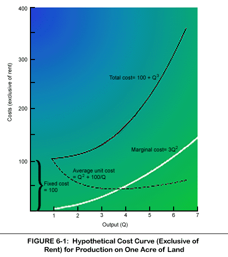
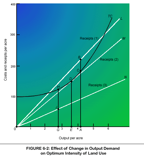
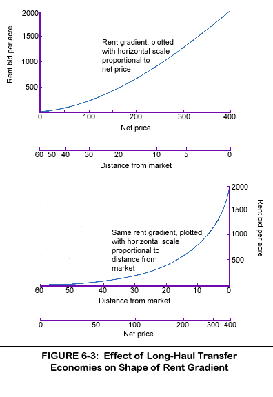
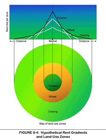
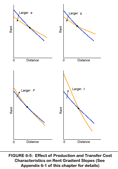
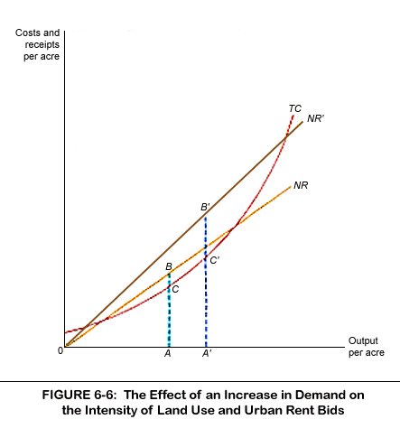
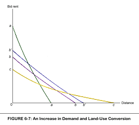
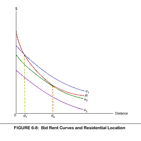